IMAGES TAKEN NEAR TO
Stornoway Drive, INVERNESS, IV3 8GD
Introduction
This page details the photographs taken nearby to Stornoway Drive, IV3 8GD by members of the Geograph project.
The Geograph project started in 2005 with the aim of publishing, organising and preserving representative images for every square kilometre of Great Britain, Ireland and the Isle of Man.

There are currently over 7.5m images from over14,400 individuals and you can help contribute to the project by visiting https://www.geograph.org.uk
Image Map (Loading...)


Getting Data...Please wait
Leaflet Map data © OpenStreetMap
Images are licensed for reuse under creativecommons.org/licenses/by-sa/2.0
Notes
- Clicking on the map will re-center to the selected point.
- The higher the marker number, the further away the image location is from the centre of the postcode.
Image Listing (6 Images Found)
Images are licensed for reuse under creativecommons.org/licenses/by-sa/2.0
Image
Details
Distance
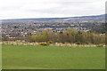
2

Construction site, Westercraigs
This is part of the Westercraigs housing development, being built for Robertson Homes. It is at the end of Stornoway Drive, a recently built street off Leachkin Road.
Image: © Craig Wallace
Taken: 26 Jun 2014
0.08 miles

4
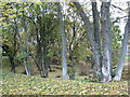
Woodland Hollow
Situated by Leachkin Road and Kinmylies Way
Image: © don cload
Taken: 26 Oct 2009
0.19 miles
5
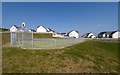
New housing at Kinmylies
A sports facility on the edge of the new houses at Kinmylies
Image: © valenta
Taken: 19 Apr 2019
0.19 miles
6

Revamped swing park/play area
This kids' play area was given a revamp when the new development was built (on the right). Craig Dunain is the hill in the background.
Image: © Alasdair MacNeill
Taken: 1 Jul 2012
0.21 miles