IMAGES TAKEN NEAR TO
Fyrish Road, FORRES, IV36 3YT
Introduction
This page details the photographs taken nearby to Fyrish Road, IV36 3YT by members of the Geograph project.
The Geograph project started in 2005 with the aim of publishing, organising and preserving representative images for every square kilometre of Great Britain, Ireland and the Isle of Man.

There are currently over 7.5m images from over14,400 individuals and you can help contribute to the project by visiting https://www.geograph.org.uk
Image Map
Images are licensed for reuse under creativecommons.org/licenses/by-sa/2.0
Notes
- Clicking on the map will re-center to the selected point.
- The higher the marker number, the further away the image location is from the centre of the postcode.
Image Listing (34 Images Found)
Images are licensed for reuse under creativecommons.org/licenses/by-sa/2.0
Image
Details
Distance
3
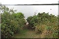
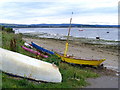
Path to Findhorn Bay
A way through dense vegetation. The bay dries out at low water.
Image: © Richard Webb
Taken: 14 Aug 2018
0.13 miles
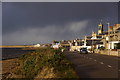
4
B9011, Findhorn
The houses have a view over the bay towards Culbin Forest.
Image: © Richard Webb
Taken: 14 Aug 2018
0.13 miles

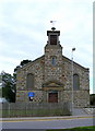
7
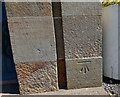
Findhorn, parish church
This benchmark is cut on the church porch, on the right hand stone surround, and on the 1st course of stone. The front of the porch faces south-west.
Image: © Mel Towler
Taken: 1 Jul 2021
0.16 miles
8
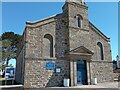
Findhorn, parish church
A wider angle of the front of Findhorn parish church. There is a clear benchmark cut on the church porch, on the right hand stone surround, on the 1st course of stone. In very good condition.
Image: © Mel Towler
Taken: 1 Jul 2021
0.16 miles
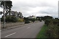
9
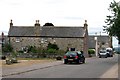
Findhorn - Street & Dumella House
The old village granary
Image: © -
Taken: 24 Jul 2006
0.16 miles
10
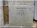
Ordnance Survey Cut Mark
This mark can be found on the wall of Findhorn Parish Church. The benchmark height is recorded as being 5.5622 metres above sea level.
For more detail see : http://www.bench-marks.org.uk/bm76211
Image: © Peter Wood
Taken: 4 Jun 2017
0.16 miles