IMAGES TAKEN NEAR TO
Findhorn, FORRES, IV36 3YN
Introduction
This page details the photographs taken nearby to IV36 3YN by members of the Geograph project.
The Geograph project started in 2005 with the aim of publishing, organising and preserving representative images for every square kilometre of Great Britain, Ireland and the Isle of Man.

There are currently over 7.5m images from over14,400 individuals and you can help contribute to the project by visiting https://www.geograph.org.uk
Image Map
Images are licensed for reuse under creativecommons.org/licenses/by-sa/2.0
Notes
- Clicking on the map will re-center to the selected point.
- The higher the marker number, the further away the image location is from the centre of the postcode.
Image Listing (76 Images Found)
Images are licensed for reuse under creativecommons.org/licenses/by-sa/2.0
Image
Details
Distance
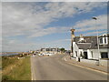
1
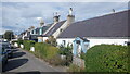
Findhorn
The outbound part of the loop of one way street.
Image: © Richard Webb
Taken: 26 Sep 2021
0.02 miles
3
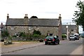
Findhorn - Street & Dumella House
The old village granary
Image: © -
Taken: 24 Jul 2006
0.04 miles
4
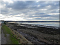
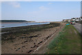
Foreshore at Findhorn
Looking over Findhorn Bay.
Image: © John Lucas
Taken: 25 Jan 2018
0.06 miles
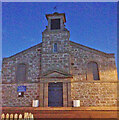
6
Findhorn War Memorial and Kinloss and Findhorn Parish Church
Image: © Douglas Nelson
Taken: 23 Aug 2023
0.06 miles
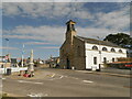
9
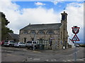
Kinloss and Findhorn Parish Church in Findhorn
Looking south-eastward.
Image: © Peter Wood
Taken: 4 Jun 2017
0.07 miles
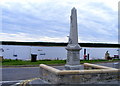
10
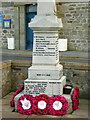
Findhorn - Kinloss Parish War Memorial
Main face.
Image: © John Lucas
Taken: 25 Jan 2018
0.07 miles