IMAGES TAKEN NEAR TO
Tedder Road, FORRES, IV36 3UT
Introduction
This page details the photographs taken nearby to Tedder Road, IV36 3UT by members of the Geograph project.
The Geograph project started in 2005 with the aim of publishing, organising and preserving representative images for every square kilometre of Great Britain, Ireland and the Isle of Man.

There are currently over 7.5m images from over14,400 individuals and you can help contribute to the project by visiting https://www.geograph.org.uk
Image Map
Images are licensed for reuse under creativecommons.org/licenses/by-sa/2.0
Notes
- Clicking on the map will re-center to the selected point.
- The higher the marker number, the further away the image location is from the centre of the postcode.
Image Listing (69 Images Found)
Images are licensed for reuse under creativecommons.org/licenses/by-sa/2.0
Image
Details
Distance
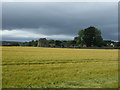
2
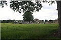
Kinloss Abbey
The old Cistercian Abbey of Kinloss, which once held power over a large area of the north-east, now resting quietly amidst farmland.
Image: © Andrew Wood
Taken: 12 Jul 2011
0.10 miles
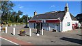
6
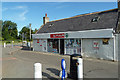
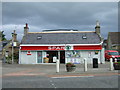
Spar at Kinloss
A busy convenience store which also accommodates the post office.
Image: © Mary and Angus Hogg
Taken: 2 Aug 2018
0.11 miles
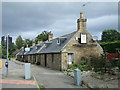
9
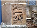
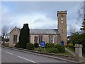
OS Benchmark
Recorded on Benchmark Database as 'Kinloss, Parish Church'.
Image: © David Bremner
Taken: 23 Apr 2023
0.12 miles