IMAGES TAKEN NEAR TO
Rafford, FORRES, IV36 2SL
Introduction
This page details the photographs taken nearby to IV36 2SL by members of the Geograph project.
The Geograph project started in 2005 with the aim of publishing, organising and preserving representative images for every square kilometre of Great Britain, Ireland and the Isle of Man.

There are currently over 7.5m images from over14,400 individuals and you can help contribute to the project by visiting https://www.geograph.org.uk
Image Map (Loading...)


Getting Data...Please wait
Leaflet Map data © OpenStreetMap
Images are licensed for reuse under creativecommons.org/licenses/by-sa/2.0
Notes
- Clicking on the map will re-center to the selected point.
- The higher the marker number, the further away the image location is from the centre of the postcode.
Image Listing (20 Images Found)
Images are licensed for reuse under creativecommons.org/licenses/by-sa/2.0
Image
Details
Distance
1
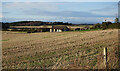
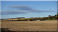
Near Sourbank
Looking across a stubble field to a new bungalow near Sourbank. The house in the woods must be Knock House, which is new enough not to be on the 1:50,000 or 1:25,000 maps yet. In the distance is a glimpse of the cliffs near Eathie on the Black Isle, with the Moray Firth at their base.
Image: © Anne Burgess
Taken: 3 Dec 2020
0.01 miles
2
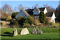
Garden Boulders
The stones, in the garden of Tulloch, caught my eye because of the sheen of the surface. They are mic-schist or phyllite, and the sheen is flakes of mica aligned by pressure when the rock was formed by metamorphosis of ancient mudstone.
Image: © Anne Burgess
Taken: 3 Dec 2020
0.04 miles
3
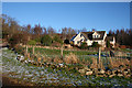
New House
One of numerous new houses in the countryside.
Image: © Anne Burgess
Taken: 17 Jan 2013
0.05 miles
4
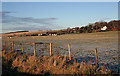
Moor of Granary
Some of the fields on the flat land at Muir of Granary. In the middle distance are two new houses, and on the skyline is the ruined Blervie Castle.
Image: © Anne Burgess
Taken: 17 Jan 2013
0.06 miles
5
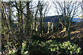
Stubble Field
Beyond the stubble field is a new bungalow near Sourbank, and in the distance is the ruined tower of Blervie Castle.
Image: © Anne Burgess
Taken: 3 Dec 2020
0.06 miles
6
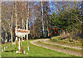
Drive to Timbernest
Timbernest is presumably the wooden house among the trees. It does not yet feature on the 1:50,000 map.
Image: © Anne Burgess
Taken: 3 Dec 2020
0.08 miles
7

Raasay
A smart new house at Sourbank, still partly unfinished by the look of the garden.
Image: © Anne Burgess
Taken: 3 Dec 2020
0.11 miles
9

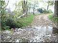
Ford and Mill
We thought this building had the look of an old mill about it. On checking the 25-inch Ordnance Survey map, it's not marked as such but there is a dam beside it. To get to it you have to ford the Rafford Burn. We didn't.
Image: © Anne Burgess
Taken: 3 Dec 2020
0.12 miles
10
Former Mill?
We thought this building had the look of an old mill about it. On checking the 25-inch Ordnance Survey map, it's not marked as such but there is a dam beside it.
Image: © Anne Burgess
Taken: 3 Dec 2020
0.13 miles