IMAGES TAKEN NEAR TO
Moy House Court, FORRES, IV36 2NZ
Introduction
This page details the photographs taken nearby to Moy House Court, IV36 2NZ by members of the Geograph project.
The Geograph project started in 2005 with the aim of publishing, organising and preserving representative images for every square kilometre of Great Britain, Ireland and the Isle of Man.

There are currently over 7.5m images from over14,400 individuals and you can help contribute to the project by visiting https://www.geograph.org.uk
Image Map
Images are licensed for reuse under creativecommons.org/licenses/by-sa/2.0
Notes
- Clicking on the map will re-center to the selected point.
- The higher the marker number, the further away the image location is from the centre of the postcode.
Image Listing (20 Images Found)
Images are licensed for reuse under creativecommons.org/licenses/by-sa/2.0
Image
Details
Distance
1
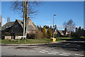
Moy House Court
A development of modern houses round a cul-de-sac behind Mains of Moy. The tower in the background belongs to the farm steading.
Image: © Anne Burgess
Taken: 11 Mar 2011
0.04 miles
2
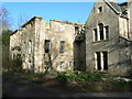
Moy House
Badly damaged by fire in the 1990s, this erstwhile fine country house is a sad sight now.
Image: © James Allan
Taken: 13 Mar 2007
0.05 miles
3
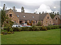
Moy House Court
A recent development of houses in traditional style with Moray sandstone featuring prominently.
Image: © Ian R Maxwell
Taken: 21 Oct 2006
0.07 miles
4
Moy House Court
A recent development of houses in traditional style with Moray sandstone featuring prominently.
Image: © Ian R Maxwell
Taken: 21 Oct 2006
0.07 miles
5
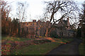
Moy House
The House of Moy has had an unfortunate recent history. It has been the subject of numerous moves to restore it, involving threats of compulsory purchase, public funding and resistance to these by the owners. In 1995 it was largely destroyed by fire, and has lain derelict ever since, despite a variety of initiatives to do something about it.
A category A listed building, it dates from the mid-18th century, the work of local stonemason Colin Williamson to a design by John Adam (1762), and was renovated in 1870 by Alexander Ross. It belonged to the family of Campbell of Cawdor, passed to the Grants of Castle Grant and then to various other owners.
Colin Williamson went on to yet greater things. He was involved as a master mason in the construction of the Capitol in Washington DC, United States of America. Appointed superintendent of stonecutters in 1793 at a salary of £400, he was dismissed in 1795 for inefficiency before the completion of the basement of the north wing.
Image: © Anne Burgess
Taken: 25 Feb 2011
0.13 miles
6
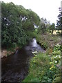
Burn near Moy House
From National Cycle Route 1.
Image: © JThomas
Taken: 19 Jul 2014
0.13 miles
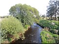
7
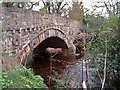
Bridge over the Muckle Burn
High river level following heavy autumnal rainfall.
Image: © Ian R Maxwell
Taken: 21 Oct 2006
0.14 miles
8
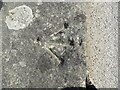
Ordnance Survey Cut Mark
This mark can be found on top of a bridge parapet across Muckle Burn near to Mains of Moy. At one time the mark had an associated rivet but this is no longer there,
The recorded details give a height of 8.9 metres above sea level.
For more detail see : https://www.bench-marks.org.uk/bm124028
Image: © Peter Wood
Taken: 12 May 2022
0.14 miles
9
Muckle Burn, Moy
Downstream view of another hogweed choked waterway.
Image: © Richard Webb
Taken: 14 Sep 2014
0.14 miles
10
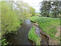
Muckle Burn
Looking north-eastward from the road bridge at Mains of Moy.
Image: © Peter Wood
Taken: 12 May 2022
0.14 miles