IMAGES TAKEN NEAR TO
Darklass Road, FORRES, IV36 2LP
Introduction
This page details the photographs taken nearby to Darklass Road, IV36 2LP by members of the Geograph project.
The Geograph project started in 2005 with the aim of publishing, organising and preserving representative images for every square kilometre of Great Britain, Ireland and the Isle of Man.

There are currently over 7.5m images from over14,400 individuals and you can help contribute to the project by visiting https://www.geograph.org.uk
Image Map (Loading...)


Getting Data...Please wait
Leaflet Map data © OpenStreetMap
Images are licensed for reuse under creativecommons.org/licenses/by-sa/2.0
Notes
- Clicking on the map will re-center to the selected point.
- The higher the marker number, the further away the image location is from the centre of the postcode.
Image Listing (27 Images Found)
Images are licensed for reuse under creativecommons.org/licenses/by-sa/2.0
Image
Details
Distance
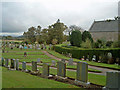
2
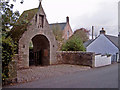
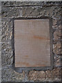
War Memorial Arch, Dyke
The entrance to the village graveyard has memorial stones inset on either side of the arch.
Image: © Ian R Maxwell
Taken: 21 Oct 2006
0.07 miles
3
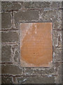
Part of the Dyke War Memorial
Another stone faces this - both sheltered under the war memorial archway at the entrance to the Dyke graveyard.
Image: © Ian R Maxwell
Taken: 21 Oct 2006
0.07 miles
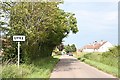
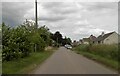
8
Dyke
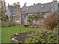
The road through the village of Dyke from the south west.
Image: © Alan hodgson
Taken: 13 Mar 2012
0.10 miles
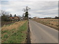
9
Unclassified road to south west of Dyke
Image: © Douglas Nelson
Taken: 20 Jun 2023
0.10 miles
10
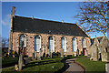
Dyke Parish Kirk
The oldest part of the kirk dates from 1628, and the main part, shown here, from 1781. It was built by Adam and Andrew Smith from Nairn or (according to Historic Scotland) James Smith from Nairn, James Smith from Auldearn and Colin Williamson, and cost £525. It was renovated in 1952, and is still in regular use.
Inconveniently, the grid line passes through the kirk. The GPS and the Historic Scotland web site place the west end in this square, but Image] is in Image There are similar views, Image], Image] and Image] in the next square.
Image] is almost unique in Scotland.
Image: © Anne Burgess
Taken: 25 Feb 2011
0.11 miles