IMAGES TAKEN NEAR TO
Webster Drive, IV36 2AG
Introduction
This page details the photographs taken nearby to Webster Drive, IV36 2AG by members of the Geograph project.
The Geograph project started in 2005 with the aim of publishing, organising and preserving representative images for every square kilometre of Great Britain, Ireland and the Isle of Man.

There are currently over 7.5m images from over14,400 individuals and you can help contribute to the project by visiting https://www.geograph.org.uk
Image Map
Images are licensed for reuse under creativecommons.org/licenses/by-sa/2.0
Notes
- Clicking on the map will re-center to the selected point.
- The higher the marker number, the further away the image location is from the centre of the postcode.
Image Listing (22 Images Found)
Images are licensed for reuse under creativecommons.org/licenses/by-sa/2.0
Image
Details
Distance
1

Rhododendron
An evergreen shrub, in the grounds of the Knockomie hotel.
Image: © Ann Harrison
Taken: 25 Jun 2010
0.08 miles

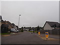
3
Building site, Forres
Off Grantown Road, where the town is about to reach the surrounding woodland.
Image: © Richard Webb
Taken: 5 Aug 2014
0.11 miles
4
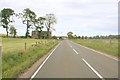
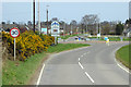
Approaching the Knockomie Hotel turn off on the left
Image: © Des Colhoun
Taken: 23 Jul 2006
0.12 miles
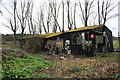
6
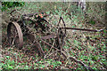
Farm machinery of yesteryear by Whiterow Farm.
Image: © Des Colhoun
Taken: 18 Mar 2007
0.14 miles

8
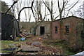
The ubiquitous red brick hut of the military past and present!
Image: © Des Colhoun
Taken: 18 Mar 2007
0.15 miles