IMAGES TAKEN NEAR TO
Cumming Street, FORRES, IV36 1NZ
Introduction
This page details the photographs taken nearby to Cumming Street, IV36 1NZ by members of the Geograph project.
The Geograph project started in 2005 with the aim of publishing, organising and preserving representative images for every square kilometre of Great Britain, Ireland and the Isle of Man.

There are currently over 7.5m images from over14,400 individuals and you can help contribute to the project by visiting https://www.geograph.org.uk
Image Map (Loading...)


Getting Data...Please wait
Leaflet Map data © OpenStreetMap
Images are licensed for reuse under creativecommons.org/licenses/by-sa/2.0
Notes
- Clicking on the map will re-center to the selected point.
- The higher the marker number, the further away the image location is from the centre of the postcode.
Image Listing (180 Images Found)
Images are licensed for reuse under creativecommons.org/licenses/by-sa/2.0
Image
Details
Distance
1
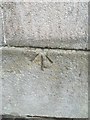
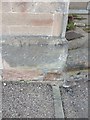
OS Pivot Bench Mark: Forres, Cumming Street
Ordnance Survey Pivot Benchmark
Image: © thejackrustles
Taken: 3 Jan 2016
0.03 miles
2
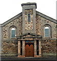
Building, Cumming Street, Forres
OS Pivot Bench Mark right hand side of building
Image: © thejackrustles
Taken: 3 Jan 2016
0.03 miles
3
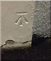
OS Cut Mark - Forres, Depository, Cumming Street
NBM Depository North East side of Cumming Street South West Face 30.3M South angle
Now a White & Company warehouse.
Image: © thejackrustles
Taken: 19 Nov 2015
0.04 miles
5
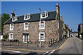
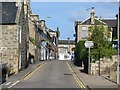
Tolbooth Street
The houses farther down Tolbooth Street are built with gables to the street, as was traditional. Later houses have their long elevation to the street.
Image: © Anne Burgess
Taken: 8 May 2008
0.07 miles
6
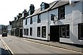
Tolbooth Street
Beyond the whiewashed Red Lion Inn are 19th century stone villas.
Image: © Anne Burgess
Taken: 8 May 2008
0.07 miles
7
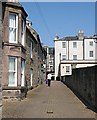
Bank Lane
The lane is used for access to the High Street through the archway to the left of the bank building.
Image: © Anne Burgess
Taken: 8 May 2008
0.08 miles
8
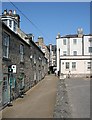
Bank Lane
The bank from which the lane takes its name is the white building on the right.
Image: © Anne Burgess
Taken: 8 May 2008
0.08 miles
9
OS Cut Mark: Forres, Tolbooth Street
Ordnance Survey Cut Mark
NBM BRITISH LEGION CLUB SE SIDE TOLBOOTH ST W ANG NW FACE
Image: © thejackrustles
Taken: 19 Oct 2014
0.08 miles