IMAGES TAKEN NEAR TO
Leys Road, FORRES, IV36 1DS
Introduction
This page details the photographs taken nearby to Leys Road, IV36 1DS by members of the Geograph project.
The Geograph project started in 2005 with the aim of publishing, organising and preserving representative images for every square kilometre of Great Britain, Ireland and the Isle of Man.

There are currently over 7.5m images from over14,400 individuals and you can help contribute to the project by visiting https://www.geograph.org.uk
Image Map
Images are licensed for reuse under creativecommons.org/licenses/by-sa/2.0
Notes
- Clicking on the map will re-center to the selected point.
- The higher the marker number, the further away the image location is from the centre of the postcode.
Image Listing (213 Images Found)
Images are licensed for reuse under creativecommons.org/licenses/by-sa/2.0
Image
Details
Distance
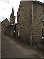
2
OS Cut Mark - Forres, Number 3a Urquhart Street
https://www.bench-marks.org.uk/bm136552
Image: © thejackrustles
Taken: 22 Apr 2021
0.03 miles
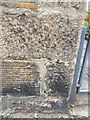
3
Gate of number 3 Urquhart Street and OS Cut Mark
Image: © thejackrustles
Taken: 22 Apr 2021
0.03 miles
5
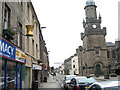
Two apothecary signs along Forres High Street
In this view northeast along High Street you can see on buildings on the left two golden pestle and mortar traditional apothecary signs outside present-day chemists or pharmacies. The first one is obvious and the second one is just above the traffic lights. On the right is the Tolbooth.
Image: © Les Shaw
Taken: 6 Aug 2006
0.04 miles
7
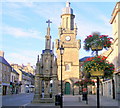
Falconer Museum
This is the east elevation of the museum. The front elevation faces north, towards the High Street. It was designed by Alexander Reid and built in 1869 with a bequest from Alexander and Hugh Falconer.
Image: © Anne Burgess
Taken: 8 May 2008
0.04 miles
8
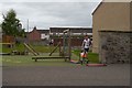
Running past a play park
During the Sprint Final, at the World Orienteering Championships. A mixture of terrain on this urban race - here runners follow a narrow path between houses, then past a play area, behind Anderson's Primary School.
The runner at the control is Giacomo Zagonel (Italy), closely followed by Jakob Edsen (Denmark).
Image: © Craig Wallace
Taken: 2 Aug 2015
0.05 miles
9
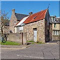
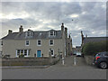
Leys Road junction with South Street Forres
A rather unusual outbuilding on the corner of Leys Road and South Street
Image: © valenta
Taken: 20 Apr 2018
0.05 miles
10
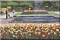
Grant Park, Forres
One of the parks and gardens which have earned Forres great success in the 'Britain in Bloom' contest. The sunken garden is on the site once occupied by Forres House.
Image: © Anne Burgess
Taken: 22 May 1983
0.05 miles