IMAGES TAKEN NEAR TO
St. Leonards Road, FORRES, IV36 1DN
Introduction
This page details the photographs taken nearby to St. Leonards Road, IV36 1DN by members of the Geograph project.
The Geograph project started in 2005 with the aim of publishing, organising and preserving representative images for every square kilometre of Great Britain, Ireland and the Isle of Man.

There are currently over 7.5m images from over14,400 individuals and you can help contribute to the project by visiting https://www.geograph.org.uk
Image Map (Loading...)


Getting Data...Please wait
Leaflet Map data © OpenStreetMap
Images are licensed for reuse under creativecommons.org/licenses/by-sa/2.0
Notes
- Clicking on the map will re-center to the selected point.
- The higher the marker number, the further away the image location is from the centre of the postcode.
Image Listing (174 Images Found)
Images are licensed for reuse under creativecommons.org/licenses/by-sa/2.0
Image
Details
Distance
1
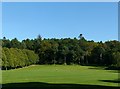
Grant Park, Forres
The western section of the park from the South Street entrance. The grounds of Forres House were purchased by the Town Council in 1924 and developed as a public park in 1924. Together with Cluny Hill and Cluny Hill Cemetery, the park is a Listed Garden & Designed Landscape.
Image: © Alan Murray-Rust
Taken: 21 Sep 2019
0.03 miles
2
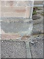
OS Cut Mark: Forres, Tolbooth Street
Ordnance Survey Cut Mark
NBM BRITISH LEGION CLUB SE SIDE TOLBOOTH ST W ANG NW FACE
Image: © thejackrustles
Taken: 19 Oct 2014
0.07 miles
3
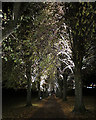
Avenue in Grant Park
Looking downhill on the avenue leading through Grant Park to Cluny Hill. The lighting is all on the downhill sides of the trees, giving them a rather ethereal look from uphill.
Image: © Anne Burgess
Taken: 9 Nov 2016
0.08 miles
4
Avenue in Grant Park
This is the avenue of trees leading up through Grant Park to Cluny Hill.
Image: © Anne Burgess
Taken: 9 Nov 2016
0.09 miles
5
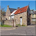
Leys Road junction with South Street Forres
A rather unusual outbuilding on the corner of Leys Road and South Street
Image: © valenta
Taken: 20 Apr 2018
0.09 miles
6
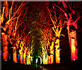
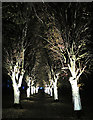
Red and Gold
This year, the trees on the approach to Cluny Hill are lit in scarlet and gold.
Image: © Anne Burgess
Taken: 13 Nov 2017
0.09 miles
7
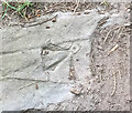
OS Cut Mark - Forres, Grant Park, South Entrance
https://www.bench-marks.org.uk/bm116470
Image: © thejackrustles
Taken: 19 Apr 2021
0.10 miles
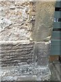
8
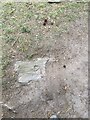
Stone with OS Cut Mark - Forres, Grant Park, South Entrance
https://www.bench-marks.org.uk/bm116470
Image: © thejackrustles
Taken: 19 Apr 2021
0.10 miles
9
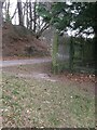
Fence Apex Grant Park, OS Cut Mark on stone near Apex
Image: © thejackrustles
Taken: 19 Apr 2021
0.10 miles
10
OS Cut Mark - Forres, Number 33 St Leonards Road
https://www.bench-marks.org.uk/bm116472
Image: © thejackrustles
Taken: 19 Apr 2021
0.10 miles