IMAGES TAKEN NEAR TO
Rowan Road, INVERNESS, IV3 5RN
Introduction
This page details the photographs taken nearby to Rowan Road, IV3 5RN by members of the Geograph project.
The Geograph project started in 2005 with the aim of publishing, organising and preserving representative images for every square kilometre of Great Britain, Ireland and the Isle of Man.

There are currently over 7.5m images from over14,400 individuals and you can help contribute to the project by visiting https://www.geograph.org.uk
Image Map (Loading...)


Getting Data...Please wait
Leaflet Map data © OpenStreetMap
Images are licensed for reuse under creativecommons.org/licenses/by-sa/2.0
Notes
- Clicking on the map will re-center to the selected point.
- The higher the marker number, the further away the image location is from the centre of the postcode.
Image Listing (13 Images Found)
Images are licensed for reuse under creativecommons.org/licenses/by-sa/2.0
Image
Details
Distance
1
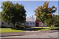
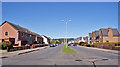
Dalneigh and Bona Church
Evangelical Church of Scotland, located in St Mary's Avenue, Dalneigh.
Image: © Richard Dorrell
Taken: 27 Aug 2014
0.04 miles
2
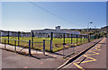
Dalneigh Primary School
Viewed here from Limetree Avenue. The school main entrance is in St Ninian Drive. This is a Local Authority Primary School with a current roll of 234 children.
Image: © Richard Dorrell
Taken: 27 Aug 2014
0.09 miles
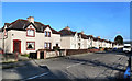
3

Laurel Avenue shops
Typical suburban shop units with flats above, here in the Dalneigh estate, Inverness. The Post Office, shown on current OS maps, is no longer open.
Image: © Richard Dorrell
Taken: 27 Aug 2014
0.09 miles
4
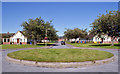
Flying saucer landing pad?
This perfectly circular flat grassed roundabout is located at the cul-de-sac end of St Mary's Avenue, Dalneigh. It look to be a perfect size and shape for parking a flying saucer.
Image: © Richard Dorrell
Taken: 27 Aug 2014
0.09 miles
5
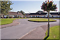
St Mary's Avenue, Dalneigh
Hanging baskets adorn the lamp posts in this cul-de-sac of senior persons bungalows.
Image: © Richard Dorrell
Taken: 27 Aug 2014
0.12 miles
6
Laurel Avenue, Dalneigh, Inverness
Looking north from the junction with Dalneigh Road. The estate was developed in the late 1940s.
Image: © Richard Dorrell
Taken: 27 Aug 2014
0.15 miles
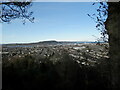
7

View over the Dalneigh area of Inverness
View from the north side of the Tomnahurich Cemetery over Dalneigh. Ord Hill and North Kessock on the horizon, where the Kessock Bridge links Inverness to The Black Isle.
Image: © valenta
Taken: 25 Dec 2019
0.15 miles
8
Dochfour Drive
A residential area near Inverness city centre.
Image: © Mary and Angus Hogg
Taken: 25 Feb 2014
0.20 miles
9
The City of Inverness below Tomnahurich
Image: © Douglas Nelson
Taken: 11 Mar 2023
0.20 miles
10
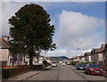
Dochfour Drive, Dalneigh
A residential street in the west side of Inverness. A large monkey puzzle tree in a garden on the left.
Image: © Craig Wallace
Taken: 9 Apr 2021
0.21 miles