IMAGES TAKEN NEAR TO
Huntly Street, INVERNESS, IV3 5HS
Introduction
This page details the photographs taken nearby to Huntly Street, IV3 5HS by members of the Geograph project.
The Geograph project started in 2005 with the aim of publishing, organising and preserving representative images for every square kilometre of Great Britain, Ireland and the Isle of Man.

There are currently over 7.5m images from over14,400 individuals and you can help contribute to the project by visiting https://www.geograph.org.uk
Image Map
Images are licensed for reuse under creativecommons.org/licenses/by-sa/2.0
Notes
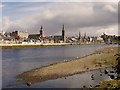
- Clicking on the map will re-center to the selected point.
- The higher the marker number, the further away the image location is from the centre of the postcode.
Image Listing (465 Images Found)
Images are licensed for reuse under creativecommons.org/licenses/by-sa/2.0
Image
Details
Distance
1
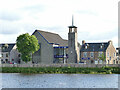
Riverside Methodist Church, Inverness
The church's website claims it to be part of "the most northerly Methodist Circuit in the United Kingdom mainland" and "the only Methodist Church in the Highlands".
Geograph to the rescue to correct that misinformation: how about Strathy on the north coast? Image This building was erected in 1965 to replace the old church in Union Street that had been destroyed by fire in 1961.
Image: © Stephen Craven
Taken: 7 Jul 2019
0.00 miles
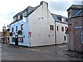
2
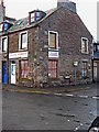
Allans Barbers, 56 Huntly Street
Located on the corner of Huntly Street and Celt Street. No barber's pole, but the window blinds or curtains are in the traditional red and white stripes, which is a nice touch.
Image: © P L Chadwick
Taken: 3 Oct 2010
0.01 miles
3
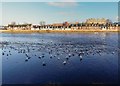
Herring Gulls on the River Ness
The Ness is tidal at this point, looking over to the terraced houses on Douglas Row
Image: © valenta
Taken: 17 Jan 2019
0.01 miles
4
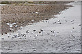
Inverness : River Ness
Seagulls on some rocks beside the River Ness.
Image: © Lewis Clarke
Taken: 24 Apr 2016
0.03 miles
5
River Ness at Inverness
The River Ness (Scottish Gaelic: Abhainn Nis) is a relatively short river about 12 miles long which flows from the northern end of Loch Ness, through Loch Dochfour, to Inverness, where it discharges into the Beauly Firth. The river is the origin of the name of the city of Inverness which is from the Scottish Gaelic: Inbhir Nis, meaning "Mouth of the Ness".
Image: © David Dixon
Taken: 4 Apr 2017
0.04 miles
6
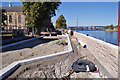
Flood defence construction works
This is Huntly Street, Inverness, looking north-west, with Friar's Bridge in the background.
Image: © Richard Dorrell
Taken: 27 Aug 2014
0.04 miles
7
Thistle Inn (1), 19 Celt Street
This independently owned pub has an interesting history. The original building dated from between 1690 and 1710, and was a coaching inn on the main road north to Beauly. In the 1860's permission was required for public houses to sell alcohol. The Thistle Inn was at first refused but apparently carried on trading, but re-applied a few years later, and was successful.
The building looks old but in fact it is a replica. The original had become unstable, and was demolished and replaced by the present building in 2003. The Mayflower lounge bar & function room was demolished in 2006, but the antique wood panels were preserved, and this part of the inn was replaced in 2008. This reconstruction must be a fairly unique event these days, when most pubs which were no longer in a fit state, would be demolished and the land used for other purposes.
Image
Image: © P L Chadwick
Taken: 3 Oct 2010
0.04 miles
8
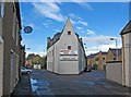
Thistle Inn (2), 19 Celt Street
The very unusual design of the rear of this back street pub, can be seen here. The pub fronts onto Celt Street, but has side frontages to King Street (on the left in this view), and to Duff Street (on the right).
Image
Image: © P L Chadwick
Taken: 3 Oct 2010
0.04 miles
9
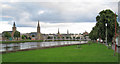
Inverness spires
A view over a small grassed area alongside Huntly Street on the west bank of the River Ness.
Image: © Richard Dorrell
Taken: 26 Aug 2013
0.05 miles
10
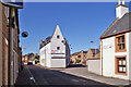
Back of the Thistle Inn
Viewed from King Street, this wedge-shaped building faces Celt Street.
Image: © Richard Dorrell
Taken: 27 Aug 2014
0.05 miles