IMAGES TAKEN NEAR TO
Bruce Gardens, INVERNESS, IV3 5EY
Introduction
This page details the photographs taken nearby to Bruce Gardens, IV3 5EY by members of the Geograph project.
The Geograph project started in 2005 with the aim of publishing, organising and preserving representative images for every square kilometre of Great Britain, Ireland and the Isle of Man.

There are currently over 7.5m images from over14,400 individuals and you can help contribute to the project by visiting https://www.geograph.org.uk
Image Map
Images are licensed for reuse under creativecommons.org/licenses/by-sa/2.0
Notes
- Clicking on the map will re-center to the selected point.
- The higher the marker number, the further away the image location is from the centre of the postcode.
Image Listing (38 Images Found)
Images are licensed for reuse under creativecommons.org/licenses/by-sa/2.0
Image
Details
Distance
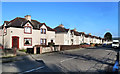
1
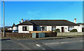
Bruce Gardens
A residential area near the centre of Inverness.
Image: © Mary and Angus Hogg
Taken: 25 Feb 2014
0.04 miles
2
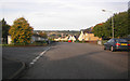
Dalneigh Road by junction of Dalneigh Crescent
Image: © Peter Bond
Taken: 14 Oct 2015
0.05 miles
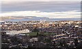
3

View over Inverness City Centre
View from the north side of the Tomnahurich Cemetery over Dalneigh towards the city centre.
The ugly office block in the centre of the image is the Highland Council building; the mustard coloured building to the right is Eden Court Theatre. Inverness Castle is in the centre-right of the image, the inner Moray Firth on the horizon.
Image: © valenta
Taken: 25 Dec 2019
0.10 miles
4
Dochfour Drive, Dalneigh
A residential street in the west side of Inverness. A large monkey puzzle tree in a garden on the left.
Image: © Craig Wallace
Taken: 9 Apr 2021
0.12 miles
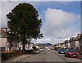
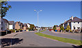
5
Laurel Avenue, Dalneigh, Inverness
Looking north from the junction with Dalneigh Road. The estate was developed in the late 1940s.
Image: © Richard Dorrell
Taken: 27 Aug 2014
0.13 miles
6

View over the Dalneigh area of Inverness
View from the north side of the Tomnahurich Cemetery over Dalneigh. Ord Hill and North Kessock on the horizon, where the Kessock Bridge links Inverness to The Black Isle.
Image: © valenta
Taken: 25 Dec 2019
0.13 miles
7
Dochfour Drive
A residential area near Inverness city centre.
Image: © Mary and Angus Hogg
Taken: 25 Feb 2014
0.14 miles
8
View over the Dalneigh area of Inverness
View from the north side of the Tomnahurich Cemetery over Dalneigh. Inverness High School dominates the foreground, with views over the Moray Firth towards the Black Isle
A view of Inverness High School here Image]
Image: © valenta
Taken: 25 Dec 2019
0.14 miles
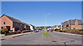
9
Laurel Avenue, Inverness
A wide dual carriageway provides vehicle access to this part of the Dalneigh housing estate. The housing here was built in the late 1940s.
Image: © Richard Dorrell
Taken: 27 Aug 2014
0.14 miles
10
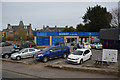
Inverness : Scotmid Co-Operative
A shop seen beside Glenuquhart Road.
Image: © Lewis Clarke
Taken: 24 Apr 2016
0.17 miles