IMAGES TAKEN NEAR TO
Bruce Gardens, INVERNESS, IV3 5EN
Introduction
This page details the photographs taken nearby to Bruce Gardens, IV3 5EN by members of the Geograph project.
The Geograph project started in 2005 with the aim of publishing, organising and preserving representative images for every square kilometre of Great Britain, Ireland and the Isle of Man.

There are currently over 7.5m images from over14,400 individuals and you can help contribute to the project by visiting https://www.geograph.org.uk
Image Map
Images are licensed for reuse under creativecommons.org/licenses/by-sa/2.0
Notes
- Clicking on the map will re-center to the selected point.
- The higher the marker number, the further away the image location is from the centre of the postcode.
Image Listing (84 Images Found)
Images are licensed for reuse under creativecommons.org/licenses/by-sa/2.0
Image
Details
Distance
2
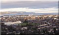
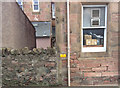
View over the Dalneigh area of Inverness
View from the north side of the Tomnahurich Cemetery over Dalneigh. Inverness High School dominates the foreground, with views over the Moray Firth towards the Black Isle
A view of Inverness High School here Image]
Image: © valenta
Taken: 25 Dec 2019
0.07 miles
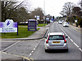
3

Inverness : Highland Council Headquarters
The council's administrative headquarters on Glenurquhart Road.
Image: © Lewis Clarke
Taken: 24 Apr 2016
0.08 miles
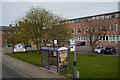
4
Glenurquhart Road (A82)
The A82, Glenurquhart Road, passing the Highland Council Offices at Inverness.
Image: © David Dixon
Taken: 4 Apr 2017
0.08 miles
5
Inverness : Highland Council Headquarters
The council building seen on Glenurquhart Road.
Image: © Lewis Clarke
Taken: 24 Apr 2016
0.08 miles
6
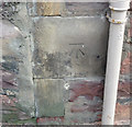
OS Cut Mark, Inverness, Glenurquhart Road
OS Cut Mark, Inverness, Glenurquhart Road
B01445 CUT MARK: COUNTY BLDGS SE SIDE GLENURQUHART RD N ANG NW FACE (ODN 6.8013m, AGL 0.7m).
Now part of Highland Council HQ, Inverness
Image: © thejackrustles
Taken: 14 Oct 2014
0.08 miles
7
OS Cut Mark, Inverness, Glenurquhart Road
OS Cut Mark, Inverness, Glenurquhart Road
B01445 CUT MARK: COUNTY BLDGS SE SIDE GLENURQUHART RD N ANG NW FACE (ODN 6.8013m, AGL 0.7m).
Now part of Highland Council HQ, Inverness
Image: © thejackrustles
Taken: 14 Oct 2014
0.08 miles
8
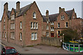
Inverness : Highland Council Headquarters
Seen from Glenurquhart Road.
Image: © Lewis Clarke
Taken: 24 Apr 2016
0.09 miles
9
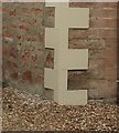
OS Cut Mark - #20 Glenurquhart Road, Inverness
B01488 - Cut Mark: Inverness, #20 Glenurquhart Road
Image: © thejackrustles
Taken: 16 Oct 2014
0.09 miles
10
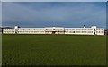
Inverness High School
What a splendid building to receive an education in. I had to stand quite some distance back from the building which overlooks the sports ground to capture the whole building. It dates from 1931 and has Category B listed status. https://britishlistedbuildings.co.uk/200379863-off-montague-row-inverness-high-school-inverness
The original school building, made from corrugated iron still stands within the school grounds Image]
Image: © valenta
Taken: 6 Feb 2020
0.09 miles