IMAGES TAKEN NEAR TO
Spey Drive, FOCHABERS, IV32 7QS
Introduction
This page details the photographs taken nearby to Spey Drive, IV32 7QS by members of the Geograph project.
The Geograph project started in 2005 with the aim of publishing, organising and preserving representative images for every square kilometre of Great Britain, Ireland and the Isle of Man.

There are currently over 7.5m images from over14,400 individuals and you can help contribute to the project by visiting https://www.geograph.org.uk
Image Map
Images are licensed for reuse under creativecommons.org/licenses/by-sa/2.0
Notes
- Clicking on the map will re-center to the selected point.
- The higher the marker number, the further away the image location is from the centre of the postcode.
Image Listing (319 Images Found)
Images are licensed for reuse under creativecommons.org/licenses/by-sa/2.0
Image
Details
Distance
1
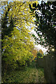
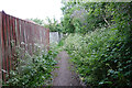
Tree-lined Lane
The Speyside Way passes along this narrow and often muddy lane between the school and the Milnecroft housing development.
Image: © Anne Burgess
Taken: 2 Nov 2021
0.01 miles
2
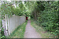
Unnamed Lane
The lane used to pass through fields, but there is now a secondary school on the right and a housing development on the left.
Image: © Anne Burgess
Taken: 20 Jun 2021
0.01 miles
3
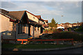
Spey Drive
This is part of the Milnecroft development, where all the streets are named after the River Spey. They are all culs-de-sac, but linked by internal footpaths.
Image: © Anne Burgess
Taken: 1 Jan 2012
0.01 miles
4
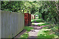
A Convenient Lane
The lane runs between the secondary school and the Sheepie's Roadie, connecting to the riverbank path network.
Image: © Anne Burgess
Taken: 28 Jul 2023
0.02 miles
5
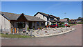
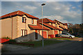
Spey Drive
Modern houses on the outskirts of Fochabers.
Image: © Anne Burgess
Taken: 24 Jul 2021
0.02 miles
6
Wild Flowers along the Lane
For reasons unknown to me, the gardens belonging to the new houses on the left have cut-off corners, which create v-plan spaces beside the path, and the path tends to follow the v, making it look as if it's overgrown in places.
Image: © Anne Burgess
Taken: 20 Jun 2021
0.03 miles
7
Milnecroft in Murk
The low cloud has never shifted all day, although the forecast was for sunshine like yesterday's.
Image: © Anne Burgess
Taken: 18 Dec 2021
0.05 miles
8
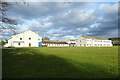
Milne's High School
The new secondary school, built in the 1980s on what was the glebe belonging to the Church of Scotland.
Image: © Anne Burgess
Taken: 28 Feb 2021
0.05 miles
9
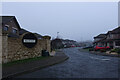
Spey Road
The reddish glow of low winter sunshine gilds the modern houses at the beginning of Spey Road.
Image: © Anne Burgess
Taken: 1 Jan 2012
0.05 miles
10

Spey Road
Various types of modern housing in Spey Road.
Image: © Anne Burgess
Taken: 18 Mar 2021
0.05 miles