IMAGES TAKEN NEAR TO
Dunkirk Road, FOCHABERS, IV32 7NZ
Introduction
This page details the photographs taken nearby to Dunkirk Road, IV32 7NZ by members of the Geograph project.
The Geograph project started in 2005 with the aim of publishing, organising and preserving representative images for every square kilometre of Great Britain, Ireland and the Isle of Man.

There are currently over 7.5m images from over14,400 individuals and you can help contribute to the project by visiting https://www.geograph.org.uk
Image Map (Loading...)


Getting Data...Please wait
Leaflet Map data © OpenStreetMap
Images are licensed for reuse under creativecommons.org/licenses/by-sa/2.0
Notes
- Clicking on the map will re-center to the selected point.
- The higher the marker number, the further away the image location is from the centre of the postcode.
Image Listing (7 Images Found)
Images are licensed for reuse under creativecommons.org/licenses/by-sa/2.0
Image
Details
Distance
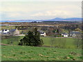
1
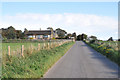
Road approaching Garmouth from the west
Image: © Steven Brown
Taken: 6 Oct 2010
0.13 miles
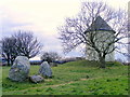
4
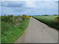
Cadgers Road giving access to Kingston
Looking north-eastward.
Image: © Peter Wood
Taken: 14 May 2022
0.16 miles
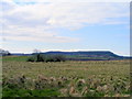
7
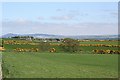
Looking towards Garmouth
Garmouth is mostly in the next square. The water tower is on the left, and on the skyline beyond is the Bin of Cullen.
Image: © Anne Burgess
Taken: 14 May 2008
0.19 miles