IMAGES TAKEN NEAR TO
High Street, FOCHABERS, IV32 7NQ
Introduction
This page details the photographs taken nearby to High Street, IV32 7NQ by members of the Geograph project.
The Geograph project started in 2005 with the aim of publishing, organising and preserving representative images for every square kilometre of Great Britain, Ireland and the Isle of Man.

There are currently over 7.5m images from over14,400 individuals and you can help contribute to the project by visiting https://www.geograph.org.uk
Image Map (Loading...)


Getting Data...Please wait
Leaflet Map data © OpenStreetMap
Images are licensed for reuse under creativecommons.org/licenses/by-sa/2.0
Notes
- Clicking on the map will re-center to the selected point.
- The higher the marker number, the further away the image location is from the centre of the postcode.
Image Listing (69 Images Found)
Images are licensed for reuse under creativecommons.org/licenses/by-sa/2.0
Image
Details
Distance
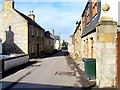
1
The Moorings
A substantial stone house on High Street.
Image: © Anne Burgess
Taken: 23 Oct 2021
0.03 miles
2

Redwing (Turdus iliacus)
A large flock of these winter visitors was feeding on the berries of the holly trees beside Garmouth War Memorial.
Image: © Anne Burgess
Taken: 11 Nov 2018
0.03 miles
3

Garmouth War Memorial (5)
A close-up view of some of the 1918 crocheted, knitted, tartan and felt poppies made by members of the Garmouth and Kingston Heritage Group to commemorate the centenary of the 1918 Armistice. Image]
Image: © Anne Burgess
Taken: 11 Nov 2018
0.03 miles
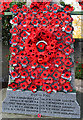
4

Garmouth War Memorial (4)
This is the central wreath on the plinth of the War Memorial, surrounded by the tartan poppies commemorating the area's war victims. Image]
Image: © Anne Burgess
Taken: 11 Nov 2018
0.03 miles
5
Garmouth War Memorial (3)
Easch of the 40 tartan poppies on the plinth of the War Memorial bears the name of one of the fallen. Image]
Image: © Anne Burgess
Taken: 10 Nov 2018
0.03 miles
6
Garmouth War Memorial (2)
The top of the decorated War Memorial is caught by the sun, but the lower part is in shadow. Image]
Image: © Anne Burgess
Taken: 11 Nov 2018
0.03 miles
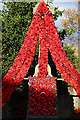
7
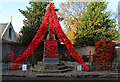
Garmouth War Memorial (1)
The War Memorial has been spectacularly decorated by members of the Garmouth and Kingston Heritage Group to commemorate the 100th anniversary of the Armistice that ended the First World War. Image]
Image: © Anne Burgess
Taken: 10 Nov 2018
0.03 miles
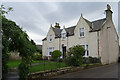
8
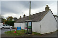
Shop Cottage
This windowless early 19th century cottage is a Category B Listed building. It is attached to the former village shop, which is hidden from this angle.
Image: © Anne Burgess
Taken: 23 Oct 2021
0.04 miles
9
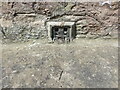
Ordnance Survey Flush Bracket G997
This partially buried flush bracket can be found on a roadside wall in Church Street, Garmouth.
The recorded details give a height of 12.7306 metres above sea level.
For more detail see : https://www.bench-marks.org.uk/bm19332
Image: © Peter Wood
Taken: 14 May 2022
0.04 miles