IMAGES TAKEN NEAR TO
Mossmill Park, FOCHABERS, IV32 7JY
Introduction
This page details the photographs taken nearby to Mossmill Park, IV32 7JY by members of the Geograph project.
The Geograph project started in 2005 with the aim of publishing, organising and preserving representative images for every square kilometre of Great Britain, Ireland and the Isle of Man.

There are currently over 7.5m images from over14,400 individuals and you can help contribute to the project by visiting https://www.geograph.org.uk
Image Map (Loading...)


Getting Data...Please wait
Leaflet Map data © OpenStreetMap
Images are licensed for reuse under creativecommons.org/licenses/by-sa/2.0
Notes
- Clicking on the map will re-center to the selected point.
- The higher the marker number, the further away the image location is from the centre of the postcode.
Image Listing (23 Images Found)
Images are licensed for reuse under creativecommons.org/licenses/by-sa/2.0
Image
Details
Distance
1
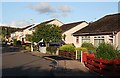
Mossmill Park
A 1970s housing development on the north side of Mosstodloch.
Image: © Anne Burgess
Taken: 13 Jun 2008
0.03 miles
2

Mossmill Park
The entrance to this late 20th century housing development.
Image: © Anne Burgess
Taken: 17 Feb 2021
0.04 miles
3

Mossmill Park
A late 20th century development on the north side of Mosstodloch.
Image: © Anne Burgess
Taken: 17 Feb 2021
0.05 miles
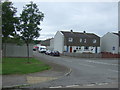
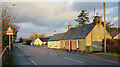
6

A Large Hole
I can just see this being popular with the residents in the houses on either side of the street.
Image: © Anne Burgess
Taken: 17 Feb 2021
0.08 miles
7
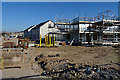
Houses under Construction
A new development on the outskirts of Mosstodloch.
Image: © Anne Burgess
Taken: 24 Apr 2020
0.12 miles
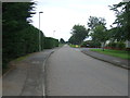
8
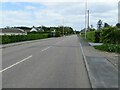
Stynie Road (B9015), Mosstodloch
Looking south-eastward.
Image: © Peter Wood
Taken: 14 May 2022
0.13 miles
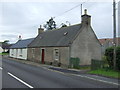
10
Cottages in Mosstodloch
The nearest one is White Cottage, then Balnacoul Croft, and after the gap is Tigh Geal (which is Gaelic for 'white house'). This road used to be the main A96, and I am sure that the occupants here are every bit as relieved as passing motorists that there is now a bypass.
Image: © Anne Burgess
Taken: 4 May 2021
0.13 miles