IMAGES TAKEN NEAR TO
FOCHABERS, IV32 7HA
Introduction
This page details the photographs taken nearby to IV32 7HA by members of the Geograph project.
The Geograph project started in 2005 with the aim of publishing, organising and preserving representative images for every square kilometre of Great Britain, Ireland and the Isle of Man.

There are currently over 7.5m images from over14,400 individuals and you can help contribute to the project by visiting https://www.geograph.org.uk
Image Map (Loading...)


Getting Data...Please wait
Leaflet Map data © OpenStreetMap
Images are licensed for reuse under creativecommons.org/licenses/by-sa/2.0
Notes
- Clicking on the map will re-center to the selected point.
- The higher the marker number, the further away the image location is from the centre of the postcode.
Image Listing (99 Images Found)
Images are licensed for reuse under creativecommons.org/licenses/by-sa/2.0
Image
Details
Distance
1
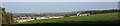
Castlehill Farm
It won't be long before the farm is engulfed by the growth of housing in the village of Fochabers.
Image: © Anne Burgess
Taken: 15 Oct 2006
0.03 miles
3

Cloud Formation (2)
A few metres and a few minutes after Image], and the cloud is already breaking up into a lacy pattern.
Image: © Anne Burgess
Taken: 22 Mar 2010
0.08 miles
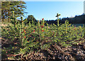
4
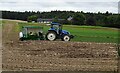
Planting Trees
A field at Castlehill Farm is being planted with tree seedlings.
Image: © Anne Burgess
Taken: 30 Aug 2021
0.10 miles
5
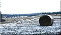
Fochabers in the Snow
Looking from the path up to Slorach's Wood towards the outskirts of the village.
Image: © Anne Burgess
Taken: 19 Feb 2010
0.10 miles
6
Cloud Formation (1)
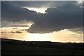
This dramatic cloud formation caught my eye against the sunset sky. It looks like the edge of a rather good wave cloud, the sort that glider pilots dream of. Wave clouds are formed when strong winds are deflected upwards by mountains, and as they descend they set up standing waves in the air mass downwind of the mountains, thus producing lenticular clouds at the top of each wave. With mountains to the south and west, such clouds are common here. See also Image'>Image
Image: © Anne Burgess
Taken: 22 Mar 2010
0.11 miles
7
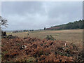
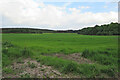
Field at Castlehill
The field is beside the track leading up into Slorach's Wood.
Image: © Anne Burgess
Taken: 16 Jan 2015
0.12 miles
8
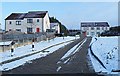
Slorach's Brae
This steeply sloping street is paved with protruding setts, making a rough surface so that it should be easier to get a car up to the top in winter weather.
Image: © Anne Burgess
Taken: 19 Feb 2010
0.12 miles
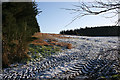
9
Future Christmas Trees
They're barely more than a handspan tall, and far too close to one another to be left in situ. They will be dug up and sold for replanting elsewhere to grow as far as they are allowed to before being harvested.
Image: © Anne Burgess
Taken: 26 Dec 2023
0.12 miles
10
Field at Castlehill
A rather anonymous-looking field, seen from a path behind the houses in the Castlehill housing estate.
Image: © Anne Burgess
Taken: 3 Jun 2021
0.12 miles