IMAGES TAKEN NEAR TO
The Wyndies, FOCHABERS, IV32 7GT
Introduction
This page details the photographs taken nearby to The Wyndies, IV32 7GT by members of the Geograph project.
The Geograph project started in 2005 with the aim of publishing, organising and preserving representative images for every square kilometre of Great Britain, Ireland and the Isle of Man.

There are currently over 7.5m images from over14,400 individuals and you can help contribute to the project by visiting https://www.geograph.org.uk
Image Map (Loading...)


Getting Data...Please wait
Leaflet Map data © OpenStreetMap
Images are licensed for reuse under creativecommons.org/licenses/by-sa/2.0
Notes
- Clicking on the map will re-center to the selected point.
- The higher the marker number, the further away the image location is from the centre of the postcode.
Image Listing (64 Images Found)
Images are licensed for reuse under creativecommons.org/licenses/by-sa/2.0
Image
Details
Distance
2
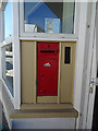
Post Box in Garmouth
I noticed that this old letter box has neither insignia nor the number of the monarch.
Image: © Anne Burgess
Taken: 6 May 2020
0.03 miles
3
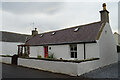
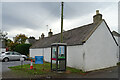
Post Office Cottage
The cottage attached to what used to be Garmouth Post Office is Category C Listed. See http://portal.historicenvironment.scot/designation/LB14823 for details.
Image: © Anne Burgess
Taken: 23 Oct 2021
0.03 miles
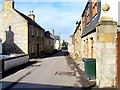
4
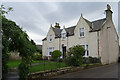
The Moorings
A substantial stone house on High Street.
Image: © Anne Burgess
Taken: 23 Oct 2021
0.04 miles
6
Falcon House
Falcon House is Catgory B Listed. See http://portal.historicenvironment.scot/designation/LB14827 for details of this late 18th century house. It is also extraordinarily difficult to photograph well thanks to it being in a very narrow street.
Image: © Anne Burgess
Taken: 23 Oct 2021
0.04 miles
7
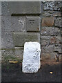
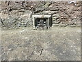
Ordnance Survey Bench Mark
The bench mark is carved in the wall of a house in Church Street.
Image: © Anne Burgess
Taken: 23 Oct 2021
0.04 miles
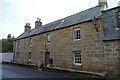
8
The Garmouth Hotel
Still a pleasant village inn, it dates back to the late 18th century and is Listed Category B.
Image: © Alan Murray-Rust
Taken: 20 Sep 2019
0.05 miles
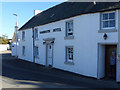
9
Shop Cottage
This windowless early 19th century cottage is a Category B Listed building. It is attached to the former village shop, which is hidden from this angle.
Image: © Anne Burgess
Taken: 23 Oct 2021
0.05 miles
10
Ordnance Survey Flush Bracket G997
This partially buried flush bracket can be found on a roadside wall in Church Street, Garmouth.
The recorded details give a height of 12.7306 metres above sea level.
For more detail see : https://www.bench-marks.org.uk/bm19332
Image: © Peter Wood
Taken: 14 May 2022
0.05 miles