IMAGES TAKEN NEAR TO
High Street, FOCHABERS, IV32 7EP
Introduction
This page details the photographs taken nearby to High Street, IV32 7EP by members of the Geograph project.
The Geograph project started in 2005 with the aim of publishing, organising and preserving representative images for every square kilometre of Great Britain, Ireland and the Isle of Man.

There are currently over 7.5m images from over14,400 individuals and you can help contribute to the project by visiting https://www.geograph.org.uk
Image Map (Loading...)


Getting Data...Please wait
Leaflet Map data © OpenStreetMap
Images are licensed for reuse under creativecommons.org/licenses/by-sa/2.0
Notes
- Clicking on the map will re-center to the selected point.
- The higher the marker number, the further away the image location is from the centre of the postcode.
Image Listing (361 Images Found)
Images are licensed for reuse under creativecommons.org/licenses/by-sa/2.0
Image
Details
Distance
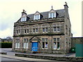
3
The Institute
The rear of the village's well-appointed hall, with car park.
Image: © Anne Burgess
Taken: 16 Jan 2015
0.02 miles
4
The Institute
This is in effect Fochabers' village hall. It contains a large and a small hall, a smaller room for meetings, and a caretaker's flat on the top floor.
Image: © Anne Burgess
Taken: 30 Jun 2007
0.03 miles
5

East Street
The curious little house at the end of the street is a lodge by the road leading to Gordon Castle.
Image: © Anne Burgess
Taken: 11 Jul 2006
0.03 miles
6
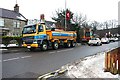
Clearing Snow in the High Street
Contractors clearing a few fragments of snow from the edge of the High Street while residents in neighbouring Streets struggle with deep wet slush on top of compacted ice. The High Street pavements on the opposite side of the road remain equally treacherous.
Image: © Anne Burgess
Taken: 15 Jan 2010
0.03 miles
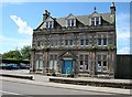
7
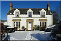
White Lodge
The house was formerly the Free Kirk manse. It is a Category B Listed building. See http://portal.historicenvironment.scot/designation/LB1600 for details.
Image: © Anne Burgess
Taken: 11 Feb 2021
0.05 miles
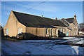
8
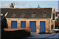
Blue Shed Doors
This is a block of sheds, probably intended as coal cellars for the houses on the east side of East Street.
Image: © Anne Burgess
Taken: 16 Jan 2015
0.05 miles
9
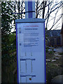
Coronavirus Lockdown - Bus Stop
Bus services have been curtailed because of the coronavirus pandemic. There are normally three services an hour, all of which have been reduced to two-hourly.
Image: © Anne Burgess
Taken: 2 Apr 2020
0.05 miles
10
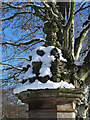
East Gatepost
The entrance to Milne's Primary School passes between a pair of carved stone gateposts. This is the top of the east gatepost.
Image: © Anne Burgess
Taken: 11 Feb 2021
0.05 miles