IMAGES TAKEN NEAR TO
George Street, FOCHABERS, IV32 7EG
Introduction
This page details the photographs taken nearby to George Street, IV32 7EG by members of the Geograph project.
The Geograph project started in 2005 with the aim of publishing, organising and preserving representative images for every square kilometre of Great Britain, Ireland and the Isle of Man.

There are currently over 7.5m images from over14,400 individuals and you can help contribute to the project by visiting https://www.geograph.org.uk
Image Map (Loading...)


Getting Data...Please wait
Leaflet Map data © OpenStreetMap
Images are licensed for reuse under creativecommons.org/licenses/by-sa/2.0
Notes
- Clicking on the map will re-center to the selected point.
- The higher the marker number, the further away the image location is from the centre of the postcode.
Image Listing (444 Images Found)
Images are licensed for reuse under creativecommons.org/licenses/by-sa/2.0
Image
Details
Distance
1
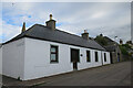
52 South Street
South Street was the southern extremity of the original planned village, and this looks like an original cottage, though the doorway has been altered, no doubt to let in more light. It is in the conservation area but not separately listed.
Image: © Anne Burgess
Taken: 14 Oct 2021
0.01 miles
2
4 and 6 George Street
These twin early 19th century cottages are Category C Listed. See http://portal.historicenvironment.scot/designation/LB1557 for details.
Image: © Anne Burgess
Taken: 14 Oct 2021
0.01 miles
3
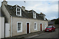
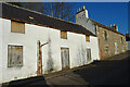
54 South Street
On the corner of South Street and George Street, No 56 is an early 19th century Category B Listed building. It is sad to see it abandoned and boarded up. See http://portal.historicenvironment.scot/designation/LB1611 for details.
Image: © Anne Burgess
Taken: 27 Feb 2021
0.01 miles
4
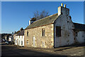
8 George Street
This cottage, dating from 1777, is the oldest house in the planned village of Fochabers. It is a Category B Listed building. See http://portal.historicenvironment.scot/designation/LB1558 for details.
Image: © Anne Burgess
Taken: 14 Oct 2021
0.01 miles
6
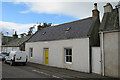
56 South Street
Like its neighbour No 54, No 56 is a Category B Listed building in a sorry state. It dates from about 1800. See http://portal.historicenvironment.scot/designation/LB1612 for details.
Image: © Anne Burgess
Taken: 27 Feb 2021
0.02 miles
7
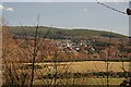
Fochabers from the Inchberry Road
The compact heart of the village, seen from the high ground on the west side of the River Spey. It won't be long before this view is totally obscured by the growing trees.
Image: © Anne Burgess
Taken: 28 Jan 2008
0.03 miles
8
Bellie Kirk
The classical columns of the portico on the north facade of Bellie Parish Kirk are only in the sunshine early on summer mornings.
Image: © Anne Burgess
Taken: 10 Jul 2006
0.03 miles
9

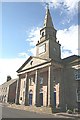
Bellie Parish Kirk
This is the rear of the building, where a bow is added to the plain rectangular building. It is original, dating from 1798, but the windows were lengthened in 1835.
Image: © Anne Burgess
Taken: 13 Feb 2019
0.03 miles
10
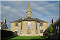
Bellie Parish Kirk
The Parish Kirk is a Category A Listed building, designed by John Baxter about 1795 as the centrepiece of the Duke of Gordon's planned village. It is a Category A Listed Building. See http://portal.historicenvironment.scot/designation/LB1616. Sadly, the corollary of being able to photograph this, the rear elevation, bathed in glorious sunshine is that the front of the building is almost always in the shade, and usually cluttered up with parked cars in front of it.
Image: © Anne Burgess
Taken: 15 Oct 2021
0.03 miles