IMAGES TAKEN NEAR TO
Drainie Road, LOSSIEMOUTH, IV31 6SF
Introduction
This page details the photographs taken nearby to Drainie Road, IV31 6SF by members of the Geograph project.
The Geograph project started in 2005 with the aim of publishing, organising and preserving representative images for every square kilometre of Great Britain, Ireland and the Isle of Man.

There are currently over 7.5m images from over14,400 individuals and you can help contribute to the project by visiting https://www.geograph.org.uk
Image Map (Loading...)


Getting Data...Please wait
Leaflet Map data © OpenStreetMap
Images are licensed for reuse under creativecommons.org/licenses/by-sa/2.0
Notes
- Clicking on the map will re-center to the selected point.
- The higher the marker number, the further away the image location is from the centre of the postcode.
Image Listing (4 Images Found)
Images are licensed for reuse under creativecommons.org/licenses/by-sa/2.0
Image
Details
Distance
1

Tornado Farewell
The Tornado aircraft that served the RAF at Lossiemouth among other places have been retired. Three of them made a farewell tour, overflying Lossiemouth as part of it. I hoped they would fly fast and low along the main runway; instead they flew across and quite high up. Very disappointing. The fourth aircraft is a Hawk from which the occasion was being photographed, or so we understand.
Image: © Anne Burgess
Taken: 21 Feb 2019
0.10 miles
2

Married Quarters at RAF Lossiemouth.
These quarters once housed Royal naval personnel when RAF Lossiemouth came under the name of HMS Fulmar.
Image: © Des Colhoun
Taken: 12 Jun 2006
0.12 miles
3
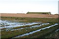
Waterlogged Fields near Westerfolds
The water table is never far below the surface in the Laich of Moray, and this autumn it seems to be almost at ground level, and today it's frozen over to boot. The structure on the skyline is on RAF Lossiemouth.
Image: © Anne Burgess
Taken: 28 Nov 2008
0.14 miles
4

Red Arrows over Moray
Precision formation flying over the Laich of Moray.
Image: © Anne Burgess
Taken: 22 Jul 2023
0.23 miles