IMAGES TAKEN NEAR TO
LOSSIEMOUTH, IV31 6SA
Introduction
This page details the photographs taken nearby to IV31 6SA by members of the Geograph project.
The Geograph project started in 2005 with the aim of publishing, organising and preserving representative images for every square kilometre of Great Britain, Ireland and the Isle of Man.

There are currently over 7.5m images from over14,400 individuals and you can help contribute to the project by visiting https://www.geograph.org.uk
Image Map (Loading...)


Getting Data...Please wait
Leaflet Map data © OpenStreetMap
Images are licensed for reuse under creativecommons.org/licenses/by-sa/2.0
Notes
- Clicking on the map will re-center to the selected point.
- The higher the marker number, the further away the image location is from the centre of the postcode.
Image Listing (23 Images Found)
Images are licensed for reuse under creativecommons.org/licenses/by-sa/2.0
Image
Details
Distance
1
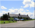
cottages at Kinneddar
On the Muirton Road.
Image: © Ann Harrison
Taken: 26 May 2009
0.01 miles
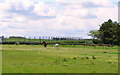
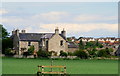
2
Looking towards Lossiemouth
Across the fields from Kinneddar.
Image: © Ann Harrison
Taken: 26 May 2009
0.03 miles
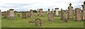
3
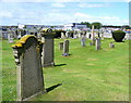
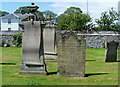
The Old Cemetery at Lossiemouth
No longer in use.
Image: © Ann Harrison
Taken: 26 May 2009
0.07 miles
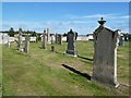
5
Kinneddar Kirkyard
The old graveyard of Kinneddar, just opposite the gates to RAF Lossiemouth.
Image: © Anne Burgess
Taken: 26 Aug 2006
0.10 miles
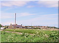
7
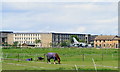
R.A.F. Lossiemouth
This is taken from the R.A.F. saddle club fields.
Image: © Ann Harrison
Taken: 26 May 2009
0.10 miles
10
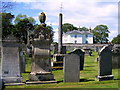
The Old Cemetery
Headstones and the cross at the old cemetery.
Image: © Ann Harrison
Taken: 26 May 2009
0.12 miles