IMAGES TAKEN NEAR TO
Tulloch's Lane, LOSSIEMOUTH, IV31 6NL
Introduction
This page details the photographs taken nearby to Tulloch's Lane, IV31 6NL by members of the Geograph project.
The Geograph project started in 2005 with the aim of publishing, organising and preserving representative images for every square kilometre of Great Britain, Ireland and the Isle of Man.

There are currently over 7.5m images from over14,400 individuals and you can help contribute to the project by visiting https://www.geograph.org.uk
Image Map (Loading...)


Getting Data...Please wait
Leaflet Map data © OpenStreetMap
Images are licensed for reuse under creativecommons.org/licenses/by-sa/2.0
Notes
- Clicking on the map will re-center to the selected point.
- The higher the marker number, the further away the image location is from the centre of the postcode.
Image Listing (79 Images Found)
Images are licensed for reuse under creativecommons.org/licenses/by-sa/2.0
Image
Details
Distance
1

Church of St Margaret, Lossiemouth
This is the local Scottish Episcopal (Anglican) church, opened in 1911.
Image: © Alan Murray-Rust
Taken: 21 Sep 2019
0.04 miles
2

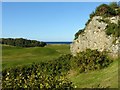
The Craig, Lossiemouth
The derivation of the house name is obvious. The crag appears to be an outcrop of what is known as the Stotfield Cherty Rock Formation, a very localised formation described by the British Geological Society as "Sedimentary rock comprising massive pale grey chert, sandy limestone, calcareous sandstone and silicified sandstone of pedogenic origin."
Image: © Alan Murray-Rust
Taken: 21 Sep 2019
0.05 miles
3
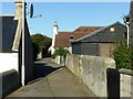
Paradise Lane, Lossiemouth
This formed part of the old village of Stotfield, the oldest of the settlements which combined to form Lossiemouth.
Image: © Alan Murray-Rust
Taken: 21 Sep 2019
0.06 miles
4
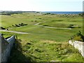
Outcrop by the golf course, Lossiemouth
The available evidence suggests that this is the Stotfield Cherty Rock Formation, a very localised formation described by the British Geological Society as "Sedimentary rock comprising massive pale grey chert, sandy limestone, calcareous sandstone and silicified sandstone of pedogenic origin." Do you call it limestone, sandstone or maybe a combination such as 'Slimeandstone'?
Image: © Alan Murray-Rust
Taken: 21 Sep 2019
0.07 miles
5
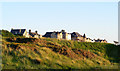
Stotfield Links
From the footpath at Tulloch's Brae. Classic Scottish seaside links golf course.
Image: © Alan Murray-Rust
Taken: 21 Sep 2019
0.09 miles
6
Luxury Apartments on Stotfield Road
These apartments cost a fortune but they have a good
view over the West Beach and the Moray Firth. Dolphin
watching from your own armchair, how cool is that?.
Image: © Ann Harrison
Taken: 29 May 2009
0.10 miles
7

Evening golf at Moray golf course
This telephoto shot was taken in late September as the sun was about to set.
Image: © Walter Baxter
Taken: 25 Sep 2015
0.12 miles
8
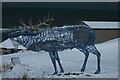
The stag which fronts the Moray Golf Club in Lossiemouth
Image: © Des Colhoun
Taken: 27 Nov 2010
0.13 miles
9
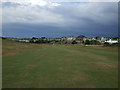
The 17th fairway Moray Golf Club - Old Course
As always a challenge on this one of the finest link courses in Scotland.
Image: © Richard Hoare
Taken: 14 Jul 2011
0.13 miles
10

Eighteenth hole at Moray Golf Club, Lossiemouth
There are two 18 hole courses; this is the penultimate stage of the Old Course, the final stage being in the building at the far end!
Image: © Alan Murray-Rust
Taken: 21 Sep 2019
0.14 miles