IMAGES TAKEN NEAR TO
Moray Street, LOSSIEMOUTH, IV31 6JD
Introduction
This page details the photographs taken nearby to Moray Street, IV31 6JD by members of the Geograph project.
The Geograph project started in 2005 with the aim of publishing, organising and preserving representative images for every square kilometre of Great Britain, Ireland and the Isle of Man.

There are currently over 7.5m images from over14,400 individuals and you can help contribute to the project by visiting https://www.geograph.org.uk
Image Map (Loading...)


Getting Data...Please wait
Leaflet Map data © OpenStreetMap
Images are licensed for reuse under creativecommons.org/licenses/by-sa/2.0
Notes
- Clicking on the map will re-center to the selected point.
- The higher the marker number, the further away the image location is from the centre of the postcode.
Image Listing (124 Images Found)
Images are licensed for reuse under creativecommons.org/licenses/by-sa/2.0
Image
Details
Distance
1
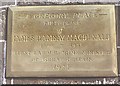
Ramsay Macdonald Plaque
The plaque beside the door of Image] tells us about itself!
Image: © Anne Burgess
Taken: 20 Jun 1983
0.10 miles
2
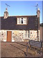
Ramsay Macdonald's Birthplace
James Ramsay Macdonald, born in 1869 in this cottage, became the first Labour Prime Minister of the United Kingdom. Image] is beside the door.
Image: © Anne Burgess
Taken: Unknown
0.10 miles
3
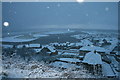
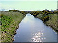
Let it snow, let it snow, let it snow!
Like so many Chinese sky lanterns, snow flakes are held in suspension in the air over the prospect of the river Lossie, the Seatown and the East Beach.
Image: © Des Colhoun
Taken: 27 Nov 2010
0.10 miles
4
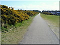
The Disused Railway Line at Lossiemouth
The whin/gorse bushes to the left have now been removed , to make
way for new houses.
Image: © Ann Harrison
Taken: 19 Apr 2008
0.10 miles
6

Chimneys and Cloud
A lenticular cloud has been formed by a standing wave in the air set up by strong wind over the mountains. I promise that this is exactly the colour captured by the camera, not altered in any way by photo editing. A really spectacular sunset!
Image: © Anne Burgess
Taken: 20 Jan 2014
0.11 miles
7
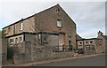
Drill Hall
The drill hall, on the corner of Church Street and Chapel Lane, was built in 1841 as a United Secession church, and was for a time St James' Church before that congregation moved to James Square then Prospect Terrace. Charles Chree Doig oversaw alterations in 1909, and the concrete extensions are clearly much later, possibly 1959. It is now operated by the Highland Reserve Forces and Cadets Association. Thanks to Chris Souter for information.
Image: © Anne Burgess
Taken: 12 Apr 2014
0.13 miles

10
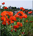
Common Poppies at Lossiemouth
The scarlet petals of Common Poppy sometimes have a black blotch
near the base and they overlap. The seed capsule is round and smooth,
with a flattened lid.
Image: © Ann Harrison
Taken: 10 Jun 2010
0.14 miles