IMAGES TAKEN NEAR TO
Clifton Road, LOSSIEMOUTH, IV31 6DJ
Introduction
This page details the photographs taken nearby to Clifton Road, IV31 6DJ by members of the Geograph project.
The Geograph project started in 2005 with the aim of publishing, organising and preserving representative images for every square kilometre of Great Britain, Ireland and the Isle of Man.

There are currently over 7.5m images from over14,400 individuals and you can help contribute to the project by visiting https://www.geograph.org.uk
Image Map (Loading...)


Getting Data...Please wait
Leaflet Map data © OpenStreetMap
Images are licensed for reuse under creativecommons.org/licenses/by-sa/2.0
Notes
- Clicking on the map will re-center to the selected point.
- The higher the marker number, the further away the image location is from the centre of the postcode.
Image Listing (452 Images Found)
Images are licensed for reuse under creativecommons.org/licenses/by-sa/2.0
Image
Details
Distance
1
The Lossie Inn, Lossiemouth
Not trading in June 2015.
Image: © Roger Cornfoot
Taken: 1 Jun 2015
0.01 miles
3
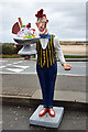
Anyone for ice cream?
The figure stands outside the 1629 Restaurant in Clifton Road, Lossiemouth, but it is taken in for the night. I photographed this on a chilly April day when an ice cream was the last thing that I wanted.
Image: © Walter Baxter
Taken: 6 Apr 2016
0.01 miles
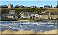
4

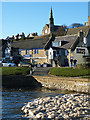
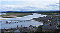
Lossiemouth
Taken from the sand dunes at Lossiemouth. Saint James church and Tower House
are on the elevated Prospect Terrace, on the esplanade below from left to right
Dawson's chemist, the 1629 restaurant,the Lossie Inn and Meile's shop.
The river Lossie runs along the esplanade and the edge of the East beach is in the foreground.
Image: © Ann Harrison
Taken: 2 Aug 2010
0.01 miles
5
Seatown Road
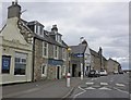
Seatown Road is the road alongside the Esplanade. On the left is the popular 1629 Restaurant upstairs and La Caverna at ground level. To the right is the Lossie Inn, which seems to be closed and is for sale. Right again is Miele's ice cream and sweet shop, and Rizza's ice cream shop is at extreme right. Up above, on the raied beach, is Prospect Terrace, the view from which amply justifies its name.
Image: © Anne Burgess
Taken: 20 Jan 2014
0.01 miles
6
The 1629
The building with the blue-painted woodwork is the popular 1629 Restaurant on the first floor, and La caverna pizzeria and bistro on the ground floor. St James' Church stands on Prospect Terrace above. In the foreground is a foam-covered eddy in the Lossie Estuary.
Image: © Anne Burgess
Taken: 20 Jan 2014
0.02 miles
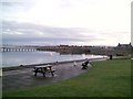
8
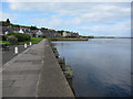
Old Harbour, Lossiemouth
The water here is the mouth of the River Lossie. This harbour is now disused, and a newer harbour operates in the Branderburgh area of the town (in grid square: Image).
Image: © Richard Dorrell
Taken: 8 Aug 2016
0.03 miles
9
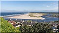
A deserted Lossiemouth East Beach
Following the closure of the footbridge from Seatown to the beach, despite it being a hot afternoon, the beach was deserted except for two windsurfers. The nearest access to the beach is 3 miles away and has been a severe blow to the local tourist industry.
Image]
Image: © valenta
Taken: 27 Jul 2019
0.03 miles
10
The River Lossie Raft Race at Lossiemouth
The raft race was much quieter this year (2009), owing to the fact that new
bye laws prevented drinking on the street.
Image: © Ann Harrison
Taken: 9 Aug 2009
0.04 miles