IMAGES TAKEN NEAR TO
ELGIN, IV30 8TF
Introduction
This page details the photographs taken nearby to IV30 8TF by members of the Geograph project.
The Geograph project started in 2005 with the aim of publishing, organising and preserving representative images for every square kilometre of Great Britain, Ireland and the Isle of Man.

There are currently over 7.5m images from over14,400 individuals and you can help contribute to the project by visiting https://www.geograph.org.uk
Image Map
Images are licensed for reuse under creativecommons.org/licenses/by-sa/2.0
Notes
- Clicking on the map will re-center to the selected point.
- The higher the marker number, the further away the image location is from the centre of the postcode.
Image Listing (6 Images Found)
Images are licensed for reuse under creativecommons.org/licenses/by-sa/2.0
Image
Details
Distance
2
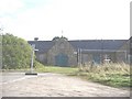
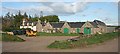
Easter Pittendreich Steading (2009)
Fenced off for renovation?
Image: © Stanley Howe
Taken: 7 Oct 2009
0.10 miles
4
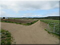
Field hosting a crop of pigs
Looking north-westward.
Image: © Peter Wood
Taken: 13 May 2022
0.18 miles
5
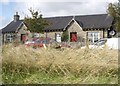
Easter Pittendreich
A possibly eighteenth century farm house and elegant nineteenth century steading at Easter Pittendreich.
Image: © Anne Burgess
Taken: 3 May 2009
0.20 miles
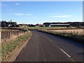
6
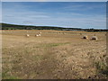
Newly Harvested Fields at Easter Pittendreich
Image: © Alan hodgson
Taken: 8 Sep 2012
0.25 miles