IMAGES TAKEN NEAR TO
Longmorn, ELGIN, IV30 8RJ
Introduction
This page details the photographs taken nearby to IV30 8RJ by members of the Geograph project.
The Geograph project started in 2005 with the aim of publishing, organising and preserving representative images for every square kilometre of Great Britain, Ireland and the Isle of Man.

There are currently over 7.5m images from over14,400 individuals and you can help contribute to the project by visiting https://www.geograph.org.uk
Image Map
Images are licensed for reuse under creativecommons.org/licenses/by-sa/2.0
Notes
- Clicking on the map will re-center to the selected point.
- The higher the marker number, the further away the image location is from the centre of the postcode.
Image Listing (5 Images Found)
Images are licensed for reuse under creativecommons.org/licenses/by-sa/2.0
Image
Details
Distance
1
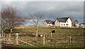
Rosebrae
Two modern houses have replaced the old farm house at Rosebrae, but the ruinous barn still stands to the right.
Image: © Anne Burgess
Taken: 5 Mar 2009
0.01 miles
2
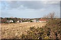
Clackmarras
The hamlet of Clackmarras grows regularly as new houses are built. The former school is to the right of the white house in the middle distance.
Image: © Anne Burgess
Taken: 5 Mar 2009
0.15 miles
3
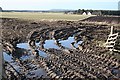
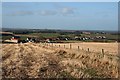
Mud, Glorious Mud!
Water-filled ruts at field gates are always handy for providing some foreground interest, but I doubt if they are quite so appealing to the farmers who have to cultivate them. The houses beyond are unnamed on the maps, and in the distance, on the left, is Longmorn Distillery.
Image: © Anne Burgess
Taken: 5 Mar 2009
0.17 miles
4
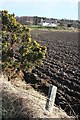
New House near Clackmarras
This is close to the site of Greenwells, which is on the 1874 six-inch Ordnance Survey map. However none of the 20th century maps shows any building or ruin here, and the road leading past it and on to Ordhill is not shown on the 19th century maps. Note the whin flowers, blooming even in late winter.
Image: © Anne Burgess
Taken: 5 Mar 2009
0.24 miles
5
Clackmarras
The hamlet of Clackmarras lines the minor road from Lhanbryde to Fogwatt. Most of the houses are relatively modern. At extreme left is the semi-derelict barn at Rosebrae.
Image: © Anne Burgess
Taken: 5 Mar 2009
0.25 miles