IMAGES TAKEN NEAR TO
Calcots, ELGIN, IV30 8NB
Introduction
This page details the photographs taken nearby to IV30 8NB by members of the Geograph project.
The Geograph project started in 2005 with the aim of publishing, organising and preserving representative images for every square kilometre of Great Britain, Ireland and the Isle of Man.

There are currently over 7.5m images from over14,400 individuals and you can help contribute to the project by visiting https://www.geograph.org.uk
Image Map
Images are licensed for reuse under creativecommons.org/licenses/by-sa/2.0
Notes
- Clicking on the map will re-center to the selected point.
- The higher the marker number, the further away the image location is from the centre of the postcode.
Image Listing (4 Images Found)
Images are licensed for reuse under creativecommons.org/licenses/by-sa/2.0
Image
Details
Distance
1
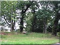
Roadside woodland
A small oakwood beside the B9103.
Image: © Richard Webb
Taken: 6 Aug 2011
0.22 miles
2
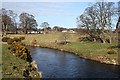
River Lossie
The view of the river from the bridge at Calcots.
Image: © Anne Burgess
Taken: 22 Mar 2007
0.22 miles
3
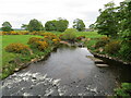
River Lossie
Looking north-westward from the road at Bridge of Calcots.
Image: © Peter Wood
Taken: 14 May 2022
0.24 miles
4
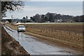
Slushy Mess
This is the B9103 road just north of Calcots on the morning after gales had blown snow and earth off the fields, covering roads with chocolate ice. This, however, pales into insignificance with the conditions only a few miles east of here. See https://www.bbc.co.uk/news/uk-scotland-north-east-orkney-shetland-56062659
Image: © Anne Burgess
Taken: 14 Feb 2021
0.24 miles