IMAGES TAKEN NEAR TO
Lhanbryde, ELGIN, IV30 8LD
Introduction
This page details the photographs taken nearby to IV30 8LD by members of the Geograph project.
The Geograph project started in 2005 with the aim of publishing, organising and preserving representative images for every square kilometre of Great Britain, Ireland and the Isle of Man.

There are currently over 7.5m images from over14,400 individuals and you can help contribute to the project by visiting https://www.geograph.org.uk
Image Map (Loading...)


Getting Data...Please wait
Leaflet Map data © OpenStreetMap
Images are licensed for reuse under creativecommons.org/licenses/by-sa/2.0
Notes
- Clicking on the map will re-center to the selected point.
- The higher the marker number, the further away the image location is from the centre of the postcode.
Image Listing (8 Images Found)
Images are licensed for reuse under creativecommons.org/licenses/by-sa/2.0
Image
Details
Distance
1
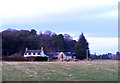
Woodside Farm
This farm is in close proximity to Lhanbryde village.
Image: © Ann Harrison
Taken: 12 Feb 2012
0.03 miles
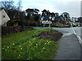
3
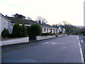
Approaching Lhanbryde
This village was bypassed in 1995 ,the road was previously part of the A96.
Image: © Ann Harrison
Taken: 12 Feb 2012
0.15 miles

5
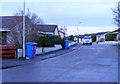
Kirkhill Drive Lhanbryde
a cul-de-sac with modern bungalows.
Image: © Ann Harrison
Taken: 12 Feb 2012
0.17 miles
6
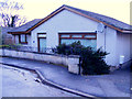
A Dwelling at Kirkhill Drive.
Kirkhill drive is a cul-de-sac of modern bungalows, each one different from the rest.
Image: © Ann Harrison
Taken: 12 Feb 2012
0.20 miles
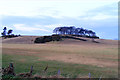
8
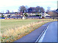
Lhanbryde
Entering Lhanbryde from the West. The village used to be on the main Aberdeen/Inverness road but is now fortunately bypassed.
Image: © Christopher Gillan
Taken: 11 Apr 2006
0.24 miles