IMAGES TAKEN NEAR TO
ELGIN, IV30 8LB
Introduction
This page details the photographs taken nearby to IV30 8LB by members of the Geograph project.
The Geograph project started in 2005 with the aim of publishing, organising and preserving representative images for every square kilometre of Great Britain, Ireland and the Isle of Man.

There are currently over 7.5m images from over14,400 individuals and you can help contribute to the project by visiting https://www.geograph.org.uk
Image Map
Images are licensed for reuse under creativecommons.org/licenses/by-sa/2.0
Notes
- Clicking on the map will re-center to the selected point.
- The higher the marker number, the further away the image location is from the centre of the postcode.
Image Listing (4 Images Found)
Images are licensed for reuse under creativecommons.org/licenses/by-sa/2.0
Image
Details
Distance
1
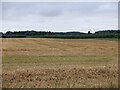
After the harvest, Darkland
Barley straw.
Image: © Richard Webb
Taken: 25 Aug 2021
0.07 miles
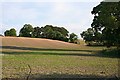
2

Darkland by Lhanbryde
Just a few houses at a crossroads. Dramatic sky!!
Image: © Christopher Gillan
Taken: 16 Apr 2006
0.13 miles
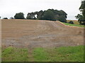
3
Near South Darkland
It was strange to see bare earth at this time of year. I have no idea what sort of crop barely shows through the surface in July.
Image: © Anne Burgess
Taken: 5 Jul 2008
0.24 miles
4
Hill, South Darkland
Probably a glacial deposit.
Image: © Richard Webb
Taken: 25 Aug 2021
0.25 miles