IMAGES TAKEN NEAR TO
ELGIN, IV30 8LA
Introduction
This page details the photographs taken nearby to IV30 8LA by members of the Geograph project.
The Geograph project started in 2005 with the aim of publishing, organising and preserving representative images for every square kilometre of Great Britain, Ireland and the Isle of Man.

There are currently over 7.5m images from over14,400 individuals and you can help contribute to the project by visiting https://www.geograph.org.uk
Image Map
Images are licensed for reuse under creativecommons.org/licenses/by-sa/2.0
Notes
- Clicking on the map will re-center to the selected point.
- The higher the marker number, the further away the image location is from the centre of the postcode.
Image Listing (12 Images Found)
Images are licensed for reuse under creativecommons.org/licenses/by-sa/2.0
Image
Details
Distance
1
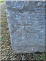
OS 1GL Bolt on Lhanbryd Parish Church
OS 1GL Bolt on Lhanbryd Parish Church - lovely example
Image: © thejackrustles
Taken: 24 Jan 2015
0.07 miles
2
St Andrew's Lhanbryd & Urquhart Church of Scotland
St Andrew's Lhanbryd & Urquhart Church of Scotland
Image: © thejackrustles
Taken: 24 Jan 2015
0.07 miles
3
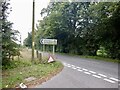
St Andrews-Lhanbryd Kirk
A short distance north of the A96 on the B9103, this kirk is well supplied with parking. Though I found the entrance/exit rather tight, so I needed both carriageways to be clear when leaving.
Image: © David Purchase
Taken: 13 Jun 2019
0.08 miles
4
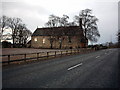
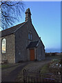
St. Andrew's-Lhanbryd and Urquhart Church.
This Church of Scotland Kirk is situated in the presbytery of Moray near the A96 main road.
Image: © Christopher Gillan
Taken: 11 Feb 2006
0.08 miles
5
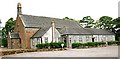
St Andrews-Lhanbryd Kirk
The range of buildings on the north of the kirk contain the kirk hall and other facilities.
Image: © Anne Burgess
Taken: 11 Jun 2008
0.08 miles
6
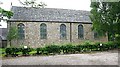
St Andrews-Lhanbryd Kirk
The south façade from the car park. Although the nearby village is Lhanbryde, the name of the parish drops the final 'e'. The white signs are to indicate parking spaces for disabled people.
Image: © Anne Burgess
Taken: 11 Jun 2008
0.08 miles
7
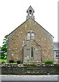
St Andrews-Lhanbryd Kirk
This is the east gable of the kirk, which is right next to the road.
Image: © Anne Burgess
Taken: 11 Jun 2008
0.09 miles
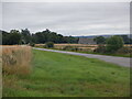
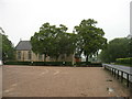
8
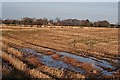
Fields Near Sheriffston
Despite the sunshine, the fields are still very wet after the weekend's snow has melted. The building in the distance is a former school now a private house. Between this house and the photographer, marked by the line of whins, is the main A96 trunk road, but there was a gap in the normally incessant traffic.
Image: © Anne Burgess
Taken: 24 Nov 2008
0.16 miles