IMAGES TAKEN NEAR TO
Kingsbarns Lane, ELGIN, IV30 8BG
Introduction
This page details the photographs taken nearby to Kingsbarns Lane, IV30 8BG by members of the Geograph project.
The Geograph project started in 2005 with the aim of publishing, organising and preserving representative images for every square kilometre of Great Britain, Ireland and the Isle of Man.

There are currently over 7.5m images from over14,400 individuals and you can help contribute to the project by visiting https://www.geograph.org.uk
Image Map (Loading...)


Getting Data...Please wait
Leaflet Map data © OpenStreetMap
Images are licensed for reuse under creativecommons.org/licenses/by-sa/2.0
Notes
- Clicking on the map will re-center to the selected point.
- The higher the marker number, the further away the image location is from the centre of the postcode.
Image Listing (7 Images Found)
Images are licensed for reuse under creativecommons.org/licenses/by-sa/2.0
Image
Details
Distance
1
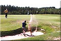
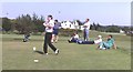
Elgin Golf Club
A player approaching the green out of a bunker at Elgin Golf Course.
Image: © Anne Burgess
Taken: Unknown
0.10 miles
2
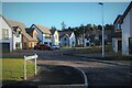
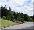
Braemar Close
A recent housing development on the south edge of Elgin.
Image: © Alan Reid
Taken: 13 Dec 2021
0.10 miles
3
Elgin Golf Club
Elgin's popular golf course is set among woodland on the southern outskirts of the town.
Image: © Anne Burgess
Taken: Unknown
0.18 miles
5
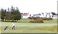
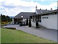
Elgin Golf Club
A player in light rough, with the extensive club house beyond.
Image: © Anne Burgess
Taken: Unknown
0.22 miles