IMAGES TAKEN NEAR TO
Dunnicaer Way, ELGIN, IV30 8AU
Introduction
This page details the photographs taken nearby to Dunnicaer Way, IV30 8AU by members of the Geograph project.
The Geograph project started in 2005 with the aim of publishing, organising and preserving representative images for every square kilometre of Great Britain, Ireland and the Isle of Man.

There are currently over 7.5m images from over14,400 individuals and you can help contribute to the project by visiting https://www.geograph.org.uk
Image Map
Images are licensed for reuse under creativecommons.org/licenses/by-sa/2.0
Notes
- Clicking on the map will re-center to the selected point.
- The higher the marker number, the further away the image location is from the centre of the postcode.
Image Listing (8 Images Found)
Images are licensed for reuse under creativecommons.org/licenses/by-sa/2.0
Image
Details
Distance
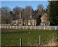
1
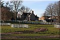
Glassgreen
The farm house, seen from the A941.
Image: © Anne Burgess
Taken: 28 Nov 2008
0.04 miles
2
Glassgreen
The road in the foreground is the A941 which goes from Elgin to Rothes, though the signposts say 'Perth', this being the next designated place of traffic importance on the A941/A95/A9 route south.
Image: © Anne Burgess
Taken: 28 Nov 2008
0.08 miles
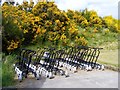
3
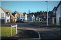
Braemar Close
A recent housing development on the south edge of Elgin.
Image: © Alan Reid
Taken: 13 Dec 2021
0.14 miles
4
Cottage at Glassgreen
This cottage is close to the A941, from which the photograph is taken.
Image: © Anne Burgess
Taken: 28 Nov 2008
0.15 miles
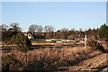
5
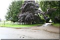
Glassgreen Farm entrance on the outskirts of Elgin.
A well established farm whose fields are quickly disappearing under the concrete of urban "development".
Image: © Des Colhoun
Taken: 23 Jun 2006
0.16 miles
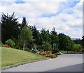
6
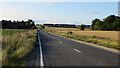
A941
Approaching the current edge of New Elgin.
Image: © Richard Webb
Taken: 4 Aug 2014
0.20 miles