IMAGES TAKEN NEAR TO
Quebec Place, ELGIN, IV30 6SA
Introduction
This page details the photographs taken nearby to Quebec Place, IV30 6SA by members of the Geograph project.
The Geograph project started in 2005 with the aim of publishing, organising and preserving representative images for every square kilometre of Great Britain, Ireland and the Isle of Man.

There are currently over 7.5m images from over14,400 individuals and you can help contribute to the project by visiting https://www.geograph.org.uk
Image Map (Loading...)


Getting Data...Please wait
Leaflet Map data © OpenStreetMap
Images are licensed for reuse under creativecommons.org/licenses/by-sa/2.0
Notes
- Clicking on the map will re-center to the selected point.
- The higher the marker number, the further away the image location is from the centre of the postcode.
Image Listing (4 Images Found)
Images are licensed for reuse under creativecommons.org/licenses/by-sa/2.0
Image
Details
Distance
2
Railway Bridge north of Linkwood distillery, Elgin, Moray.
Image: © Des Colhoun
Taken: 23 Jun 2006
0.18 miles
3
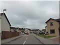
St Andrews Road
Part of the housing estate at Pinefield on the eastern edge of Elgin.
Image: © Anne Burgess
Taken: 28 Nov 2008
0.23 miles
4
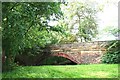
Bypassed Bridge
A bridge over a walkway bypassed by the new link road and roundabout.
Image: © Andrew Wood
Taken: 19 Jun 2009
0.23 miles