IMAGES TAKEN NEAR TO
School Walk, ELGIN, IV30 6ES
Introduction
This page details the photographs taken nearby to School Walk, IV30 6ES by members of the Geograph project.
The Geograph project started in 2005 with the aim of publishing, organising and preserving representative images for every square kilometre of Great Britain, Ireland and the Isle of Man.

There are currently over 7.5m images from over14,400 individuals and you can help contribute to the project by visiting https://www.geograph.org.uk
Image Map
Images are licensed for reuse under creativecommons.org/licenses/by-sa/2.0
Notes
- Clicking on the map will re-center to the selected point.
- The higher the marker number, the further away the image location is from the centre of the postcode.
Image Listing (7 Images Found)
Images are licensed for reuse under creativecommons.org/licenses/by-sa/2.0
Image
Details
Distance
1
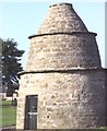
New Elgin Doocot
This is where the then laird would have kept pigeons for eggs and fresh meat in winter. It now stands in a park.
Image: © Anne Burgess
Taken: 8 Aug 1983
0.03 miles
2
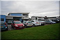
Car Parking area,New Elgin
Just off Thornhill Road.
Image: © jeff collins
Taken: 23 Jan 2014
0.20 miles
3
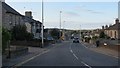
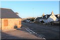
Main Street, New Elgin
Southern suburbs of Elgin along the A941. Fuel at the filling station was going for about the same price as the more competitive Central Scotland filling stations
(£1.31p / l)
Image: © Richard Webb
Taken: 4 Aug 2014
0.21 miles
4
Looking down Thornhill Road
On the outskirts of New Elgin.
Image: © jeff collins
Taken: 23 Jan 2014
0.22 miles
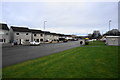
6
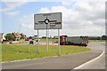
The new roundabout , New Elgin.
The A941 runs left to right in this picture.
Image: © Des Colhoun
Taken: 14 Jun 2006
0.24 miles
7
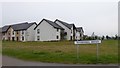
New housing at Thornhill Road, New Elgin
Image: © Alpin Stewart
Taken: 23 Jul 2017
0.24 miles