IMAGES TAKEN NEAR TO
Linkwood Road, ELGIN, IV30 6DH
Introduction
This page details the photographs taken nearby to Linkwood Road, IV30 6DH by members of the Geograph project.
The Geograph project started in 2005 with the aim of publishing, organising and preserving representative images for every square kilometre of Great Britain, Ireland and the Isle of Man.

There are currently over 7.5m images from over14,400 individuals and you can help contribute to the project by visiting https://www.geograph.org.uk
Image Map
Images are licensed for reuse under creativecommons.org/licenses/by-sa/2.0
Notes
- Clicking on the map will re-center to the selected point.
- The higher the marker number, the further away the image location is from the centre of the postcode.
Image Listing (17 Images Found)
Images are licensed for reuse under creativecommons.org/licenses/by-sa/2.0
Image
Details
Distance
2
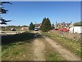
Gravel parking area, Elgin auction mart
Image: © Steven Brown
Taken: 23 Apr 2022
0.08 miles
3
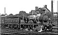
Ex-GNofS 4-4-0 at Elgin
Seen from the ex-Great North of Scotland Elgin station, where the lines from Aberdeen via Huntley and via the Buchan Coast, also the branch from Lossiemouth, combine and connect with the ex-Highland line from Keith to Inverness, a GNSR 4-4-0 is engaged in shunting - but then the GNoSR had virtually no other types than 4-4-0s, for all duties. This is Johnson/Pickersgill 4-4-0 (LNER class D41) No. 2251 (No. 6907 until 1946), built 2/1898 and withdrawn as No. 62251 in 11/51; here still in LNER livery.
Image: © Ben Brooksbank
Taken: 26 Aug 1948
0.10 miles
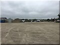
4
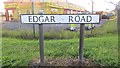
New Elgin Road
A shuttered showroom on the A941 at the junction with Edgar Road.
Image: © Richard Webb
Taken: 4 Aug 2014
0.12 miles
5

Elgin Goods Yard and former GNSR station flooded, July 1997
View eastward, towards Lossiemouth, Buckie etc.: ex-GNSR. No trains were running! See also Image] and Image
Image: © Ben Brooksbank
Taken: 3 Jul 1997
0.14 miles
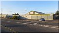
7
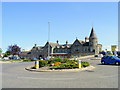
The Former Elgin Railway Station
This is now a business centre.This was a very busy station in its
heyday with five rail links. The new replacement station nearby, is
served only by the Aberdeen to Inverness line.
Image: © Ann Harrison
Taken: 19 May 2008
0.17 miles
8
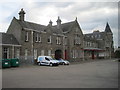
Elgin (East) railway station (site), Moray
The original terminus station was opened on this site in 1852 by the Moray Railway, and was replaced by this station building in 1902 by the Great North of Scotland Railway. It closed in 1968.
Forecourt. It is only a few hundred metres from the former Highland Railway's station at Elgin (West), on the Aberdeen-Inverness line - see Image
Image: © Nigel Thompson
Taken: 24 May 2017
0.18 miles
9
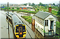
Flooded railway at Elgin, July 1997
View eastward at Elgin East Box - with nothing moving. The Class 158 DMU is marooned. Bearing left are the ex-GNSR lines to Lossiemouth and to the Coast Line via Buckie, also Keith via Craigellachie; straight ahead is the ex- Highland line direct to Keith etc. (See also Image]).
Image: © Ben Brooksbank
Taken: 3 Jul 1997
0.19 miles
10
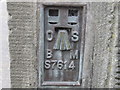
Ordnance Survey Flush Bracket S7614
This can be found on the wall of one of the buildings at the railway station.
For more detail see : http://www.bench-marks.org.uk/bm21064
Image: © Peter Wood
Taken: 2 Oct 2012
0.20 miles