IMAGES TAKEN NEAR TO
Sigurd Way, ELGIN, IV30 5ZG
Introduction
This page details the photographs taken nearby to Sigurd Way, IV30 5ZG by members of the Geograph project.
The Geograph project started in 2005 with the aim of publishing, organising and preserving representative images for every square kilometre of Great Britain, Ireland and the Isle of Man.

There are currently over 7.5m images from over14,400 individuals and you can help contribute to the project by visiting https://www.geograph.org.uk
Image Map (Loading...)


Getting Data...Please wait
Leaflet Map data © OpenStreetMap
Images are licensed for reuse under creativecommons.org/licenses/by-sa/2.0
Notes
- Clicking on the map will re-center to the selected point.
- The higher the marker number, the further away the image location is from the centre of the postcode.
Image Listing (17 Images Found)
Images are licensed for reuse under creativecommons.org/licenses/by-sa/2.0
Image
Details
Distance
1
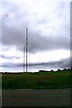
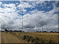
Radio Masts at Burghead
The radio masts prominent on the outskirts of Burghead.
Image: © Andrew Wood
Taken: 15 Jun 2009
0.04 miles
4

New Houses at St Aethans
There used to be a hotel up here, but the surrounding land is now all built over with somequite elaborate new houses.
Image: © Anne Burgess
Taken: 30 Sep 2010
0.11 miles
5
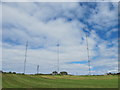
Radio Masts on Clarkly Hill
Taken from the sand spit at the mouth of the Findhorn river just after dawn.
Image: © Bob Embleton
Taken: 28 Aug 2007
0.13 miles
7
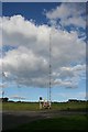
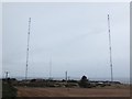
Burghead Radio Masts
These are two of the three masts just outside Burghead which transmit Radio 4 on long wave and Radio 5 and Radio Scotland on medium wave. The tallest of the three is about 240 metres tall.
Image: © Anne Burgess
Taken: 30 Sep 2010
0.14 miles
8
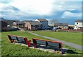
St Aethans View
A fine viewpoint in the St Aethans part of Burghead.
Image: © Mary and Angus Hogg
Taken: 24 Mar 2015
0.14 miles
9
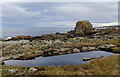
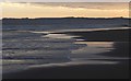
Rock Stack
The pool is out of reach of all but the highest tides, and may have been topped up by recent heavy rain.
Image: © Anne Burgess
Taken: 19 Dec 2020
0.23 miles
10
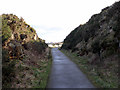
Old railway cutting
The route of the line from Burghead to Hopeman is now used by the Moray Coastal Trail.
Image: © John Lucas
Taken: 26 Feb 2020
0.24 miles