IMAGES TAKEN NEAR TO
Hutcheon Street, ELGIN, IV30 5SQ
Introduction
This page details the photographs taken nearby to Hutcheon Street, IV30 5SQ by members of the Geograph project.
The Geograph project started in 2005 with the aim of publishing, organising and preserving representative images for every square kilometre of Great Britain, Ireland and the Isle of Man.

There are currently over 7.5m images from over14,400 individuals and you can help contribute to the project by visiting https://www.geograph.org.uk
Image Map (Loading...)


Getting Data...Please wait
Leaflet Map data © OpenStreetMap
Images are licensed for reuse under creativecommons.org/licenses/by-sa/2.0
Notes
- Clicking on the map will re-center to the selected point.
- The higher the marker number, the further away the image location is from the centre of the postcode.
Image Listing (59 Images Found)
Images are licensed for reuse under creativecommons.org/licenses/by-sa/2.0
Image
Details
Distance
1
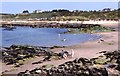
Hopeman East Beach
The sandy beach east of the harbour at Hopeman has added variety in shape of several rocky outcrops. Its popularity can be gauged by the numbers of beach huts on the far side of the bay. The large house on the skyline is Hopeman Lodge, where there is holiday accommodation available.
Image: © Anne Burgess
Taken: 19 Jun 1983
0.02 miles

3
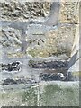
OS Cut Mark 57 Harbour Street, Hopeman
OS Cut Mark 57 Harbour Street, Hopeman, nice clear mark
Image: © thejackrustles
Taken: 24 Apr 2015
0.06 miles
4
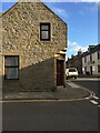
57 Harbour Street, Hopeman
57 Harbour Street, Hopeman on a sunny day
Image: © thejackrustles
Taken: 24 Apr 2015
0.06 miles
5
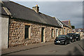
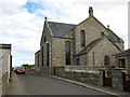
Former Drill Hall
This building was originally Hopeman Infant School, but was bought by officers of Burghead Artillery Volunteers for conversion into a drill hall in 1901. Repairs were carried out in 1909 by Charles Chree Doig, and then it was in use as a drill hall throughout the First World War. In 1937, a branch of the Scottish Women's Rural Institute was founded here. The building has now been converted into houses.
Image: © Anne Burgess
Taken: 12 Apr 2014
0.08 miles
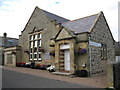
7
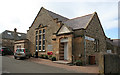
Hopeman Memorial Hall
The hall was built in memory of villagers who fell in the First World War. It was opened in 1925, and continues to serve the community.
Image: © Anne Burgess
Taken: 12 Apr 2014
0.08 miles
8
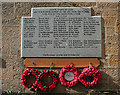
Hopeman War Memorial
The war memorial is a simple plaque of polished granite beside the door of the Memorial Hall, where every user of the hall passes by. A very good way of keeping the names where they will always be seen.
Image: © Anne Burgess
Taken: 12 Apr 2014
0.08 miles
9
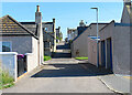
A Street with No Name?
None of the maps I have consulted names this street; some don't even show it. It runs all the way from the north to the south edges of the village.
Image: © Anne Burgess
Taken: 26 Jul 2023
0.09 miles