IMAGES TAKEN NEAR TO
Duffus, ELGIN, IV30 5QS
Introduction
This page details the photographs taken nearby to IV30 5QS by members of the Geograph project.
The Geograph project started in 2005 with the aim of publishing, organising and preserving representative images for every square kilometre of Great Britain, Ireland and the Isle of Man.

There are currently over 7.5m images from over14,400 individuals and you can help contribute to the project by visiting https://www.geograph.org.uk
Image Map
Images are licensed for reuse under creativecommons.org/licenses/by-sa/2.0
Notes
- Clicking on the map will re-center to the selected point.
- The higher the marker number, the further away the image location is from the centre of the postcode.
Image Listing (5 Images Found)
Images are licensed for reuse under creativecommons.org/licenses/by-sa/2.0
Image
Details
Distance
1
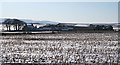
Plewlands
A large farm with extensive outbuildings, pleasantly situated on the north slope above the Laich of Moray.
Image: © Anne Burgess
Taken: 21 Feb 2010
0.01 miles
2
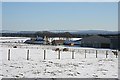
Plewlands
The farm house stands to the east of the extensive range of barns and byres, with a fine view to the south.
Image: © Anne Burgess
Taken: 21 Feb 2010
0.08 miles
3
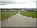
Plewlands Farm near Lossiemouth
This seems to be a large and well organised modern farm
Image: © Christopher Gillan
Taken: 14 Apr 2006
0.11 miles
4
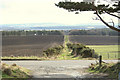
Across the road to lane leading to Gordonstoun
Image: © Des Colhoun
Taken: 2 Mar 2008
0.20 miles
5
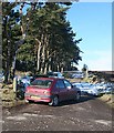
Path to the Coastguard Station
The small parking area at the gate is popular on this sunny Sunday with people walking up to the old coastguard station.
Image: © Anne Burgess
Taken: 21 Feb 2010
0.24 miles