IMAGES TAKEN NEAR TO
Duffus, ELGIN, IV30 5QR
Introduction
This page details the photographs taken nearby to IV30 5QR by members of the Geograph project.
The Geograph project started in 2005 with the aim of publishing, organising and preserving representative images for every square kilometre of Great Britain, Ireland and the Isle of Man.

There are currently over 7.5m images from over14,400 individuals and you can help contribute to the project by visiting https://www.geograph.org.uk
Image Map (Loading...)


Getting Data...Please wait
Leaflet Map data © OpenStreetMap
Images are licensed for reuse under creativecommons.org/licenses/by-sa/2.0
Notes
- Clicking on the map will re-center to the selected point.
- The higher the marker number, the further away the image location is from the centre of the postcode.
Image Listing (6 Images Found)
Images are licensed for reuse under creativecommons.org/licenses/by-sa/2.0
Image
Details
Distance
1
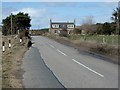
Williamston near Lossiemouth
House to the south of the Lossie/Hopeman road.
Image: © Christopher Gillan
Taken: 14 Apr 2006
0.03 miles
3
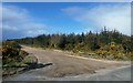
This Way To The Caves
The track gives access to the coast and some interesting features. Viewed at the junction of the B9040 and the B9012.
Image: © Mary and Angus Hogg
Taken: 24 Mar 2015
0.13 miles
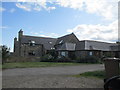
5
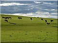
Cattle at Begrow
This evening view of a livestock field on the west side of Duffus was taken in early September.
Image: © Walter Baxter
Taken: 8 Sep 2013
0.20 miles
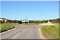
6
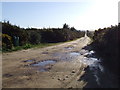
Track to dinosaur footprints
off to do a geocache near here and parked at the end of the rough track, the B9040 can be seen in the distance. If you take the track to the left of this shot you will find a collection of dinosaur footprints discovered while blasting a quarry nearby.
Image: © Richard cattel
Taken: 3 Jan 2007
0.22 miles