IMAGES TAKEN NEAR TO
Duffus, ELGIN, IV30 5QP
Introduction
This page details the photographs taken nearby to IV30 5QP by members of the Geograph project.
The Geograph project started in 2005 with the aim of publishing, organising and preserving representative images for every square kilometre of Great Britain, Ireland and the Isle of Man.

There are currently over 7.5m images from over14,400 individuals and you can help contribute to the project by visiting https://www.geograph.org.uk
Image Map
Images are licensed for reuse under creativecommons.org/licenses/by-sa/2.0
Notes
- Clicking on the map will re-center to the selected point.
- The higher the marker number, the further away the image location is from the centre of the postcode.
Image Listing (5 Images Found)
Images are licensed for reuse under creativecommons.org/licenses/by-sa/2.0
Image
Details
Distance
1
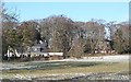
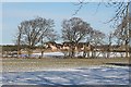
Former Manse
The house to the right is a former manse, and its steading, hidden by the trees to the left, has been converted into a house.
Image: © Anne Burgess
Taken: 21 Feb 2010
0.05 miles
2
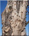
A Gnarled Tree Trunk
I speculate that this may have been an elm killed by Dutch Elm Disease.
Image: © Anne Burgess
Taken: 21 Feb 2010
0.09 miles
4
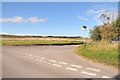
Bales by the Roadside
The row of bales follows the line of the minor road. This is viewed from the other side, over a rutted field.
Image: © Anne Burgess
Taken: 21 Feb 2010
0.11 miles
5
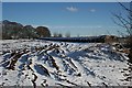
Phillaxdale
A cluster of new houses beside the traditional farm house at Phillaxdale, seen through the trees forming the field boundary.
Image: © Anne Burgess
Taken: 21 Feb 2010
0.16 miles