IMAGES TAKEN NEAR TO
ELGIN, IV30 5PU
Introduction
This page details the photographs taken nearby to IV30 5PU by members of the Geograph project.
The Geograph project started in 2005 with the aim of publishing, organising and preserving representative images for every square kilometre of Great Britain, Ireland and the Isle of Man.

There are currently over 7.5m images from over14,400 individuals and you can help contribute to the project by visiting https://www.geograph.org.uk
Image Map (3 Images)


Getting Data...Please wait
Leaflet Map data © OpenStreetMap
Images are licensed for reuse under creativecommons.org/licenses/by-sa/2.0
Notes
- Clicking on the map will re-center to the selected point.
- The higher the marker number, the further away the image location is from the centre of the postcode.
Image Listing (3 Images Found)
Images are licensed for reuse under creativecommons.org/licenses/by-sa/2.0
Image
Details
Distance
1
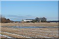
West Mains
A winter view of Image], with an ephemeral pond in the foreground field.
Image: © Anne Burgess
Taken: 20 Feb 2010
0.15 miles
2
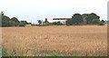
West Mains
One of the farms on the flat land of the Laich of Moray. 'Laich' means low-lying land. The Loch of Spynie covered much of the Laich until drained in the early 19th century. A winter view is here Image
Image: © Anne Burgess
Taken: 26 Aug 2006
0.18 miles
