IMAGES TAKEN NEAR TO
South Park Court, Hay Street, ELGIN, IV30 1NJ
Introduction
This page details the photographs taken nearby to South Park Court, Hay Street, IV30 1NJ by members of the Geograph project.
The Geograph project started in 2005 with the aim of publishing, organising and preserving representative images for every square kilometre of Great Britain, Ireland and the Isle of Man.

There are currently over 7.5m images from over14,400 individuals and you can help contribute to the project by visiting https://www.geograph.org.uk
Image Map
Images are licensed for reuse under creativecommons.org/licenses/by-sa/2.0
Notes
- Clicking on the map will re-center to the selected point.
- The higher the marker number, the further away the image location is from the centre of the postcode.
Image Listing (91 Images Found)
Images are licensed for reuse under creativecommons.org/licenses/by-sa/2.0
Image
Details
Distance
1
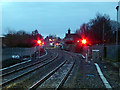
Red for danger
The view west from the end of the platform at Elgin station.
Image: © John Lucas
Taken: 25 Jan 2018
0.06 miles
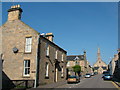
5
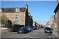
South Guildry Street
An old residential street lined with stone-built traditional houses.
Image: © Anne Burgess
Taken: 22 Mar 2007
0.10 miles
6
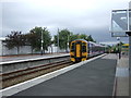
Elgin Railway Station
ScotRail class 158 train No. 158704 departing for Inverness.
Image: © JThomas
Taken: 19 Jul 2014
0.10 miles
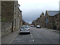
7
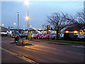
Station Road Elgin
With the railway station car park just across the road.
Image: © John Lucas
Taken: 25 Jan 2018
0.10 miles
9
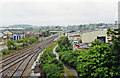
Elgin station, flooded July 1997
View westward from the New Elgin Road bridge, towards the ex-Highland Railway (West) station, Forres and Inverness. The line curving underneath was the ex-GNSR line to the GNS East station (closed 6/5/68), to Keith via Craigellachie (closed 4/11/68), thence Aberdeen, also Lossiemouth (closed 28/3/66) and Cairnie Junction via Buckie (closed 6/5/68). The double line going left is the extant, ex-Highland, line to Keith, thence Aberdeen. On this day, all trains were suspended owing to the floods - see also Image
Image: © Ben Brooksbank
Taken: 3 Jul 1997
0.12 miles
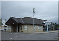
10
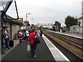
Elgin Station
Awaiting the 0800 to Aberdeen.
Image: © Richard Webb
Taken: 6 Aug 2011
0.12 miles