IMAGES TAKEN NEAR TO
Pansport Road, ELGIN, IV30 1HD
Introduction
This page details the photographs taken nearby to Pansport Road, IV30 1HD by members of the Geograph project.
The Geograph project started in 2005 with the aim of publishing, organising and preserving representative images for every square kilometre of Great Britain, Ireland and the Isle of Man.

There are currently over 7.5m images from over14,400 individuals and you can help contribute to the project by visiting https://www.geograph.org.uk
Image Map (Loading...)


Getting Data...Please wait
Leaflet Map data © OpenStreetMap
Images are licensed for reuse under creativecommons.org/licenses/by-sa/2.0
Notes
- Clicking on the map will re-center to the selected point.
- The higher the marker number, the further away the image location is from the centre of the postcode.
Image Listing (242 Images Found)
Images are licensed for reuse under creativecommons.org/licenses/by-sa/2.0
Image
Details
Distance
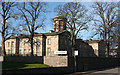
1
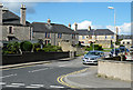
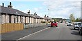
Pansport Place
Some of the substantial stone council housing near Pans Port.
Image: © Anne Burgess
Taken: 11 May 2011
0.02 miles
2
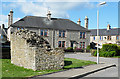
Mediaeval Masonry
This fragment of masonry in Pansport Place is a remnant of the wall which once surrounded the Cathedral precinct. And yes, it is at a slightly odd angle compared to the council house behind.
Image: © Anne Burgess
Taken: 11 May 2011
0.03 miles
3
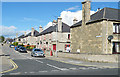
Pansport Place
The former council housing around Pans Port is of good solid stone construction.
Image: © Anne Burgess
Taken: 11 May 2011
0.04 miles
4
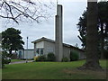
Church of Jesus Christ of Latter Day Saints
Image: © JThomas
Taken: 20 Jul 2014
0.06 miles
5
Chanonry Road
Low-rise housing in a quiet street just off East Road.
Image: © Anne Burgess
Taken: 8 May 2009
0.06 miles
6
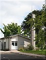
Church of Jesus Christ of Latter Day Saints
The entrance and tower at the west end of the church. The adherents of the Church of Jesus Christ of Latter Day Saints are informally known as Mormons because their sacred book, beside the Christian Bible, is the Book of Mormon.
Image: © Anne Burgess
Taken: 8 May 2009
0.06 miles
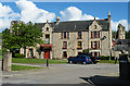
7
A96 junction with Maisondieu Road
In Elgin, Morayshire.
Image: © Stanley Howe
Taken: 30 May 2015
0.07 miles
8
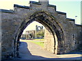
Pans Port
Pans Port an early 16th century gateway to the Cathedral, once contained
heavy wooden gates and a portcullis.
Image: © Ann Harrison
Taken: 19 May 2008
0.07 miles
9
Anderson's Institution
Andrew Anderson (c 1747-1824) was brought up in Elgin. His mother, Marjorie Gilzean, was destitute after the death of her parents and of her husband, also Andrew Anderson. They were so poor that they lived in the ruins of the Cathedral, and it is said that Andrew's cradle was the font in the anteroon beside the chapter house. Young Andrew joined the Army and rose through the ranks to become a general. He left £70,000 to build the Elgin Institution for the Support of Old Age and Education of Youth, and this building, designed by Archibald Simpson, was built in 1830-1833. Initially the building provided a school for 50 resident children, plus accommodation for 10 old people. It is now a care home for elderly people. See http://www.andersonscarehome.co.uk/
Image: © Anne Burgess
Taken: 10 Apr 2014
0.08 miles
10
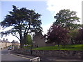
South College House
In its heyday the Cathedral, of which the towers can be seen in the background, was surrounded by the manses of the Cathedral officers and dignitaries. The names North and South College recall two of these. The actual building now on the site of South College is of a much later date, though parts of the 16th century building may lurk under the later walls.
Image: © Anne Burgess
Taken: 11 May 2011
0.08 miles