IMAGES TAKEN NEAR TO
ROGART, IV28 3YF
Introduction
This page details the photographs taken nearby to IV28 3YF by members of the Geograph project.
The Geograph project started in 2005 with the aim of publishing, organising and preserving representative images for every square kilometre of Great Britain, Ireland and the Isle of Man.

There are currently over 7.5m images from over14,400 individuals and you can help contribute to the project by visiting https://www.geograph.org.uk
Image Map (10 Images)


Getting Data...Please wait
Leaflet Map data © OpenStreetMap
Images are licensed for reuse under creativecommons.org/licenses/by-sa/2.0
Notes
- Clicking on the map will re-center to the selected point.
- The higher the marker number, the further away the image location is from the centre of the postcode.
Image Listing (10 Images Found)
Images are licensed for reuse under creativecommons.org/licenses/by-sa/2.0
Image
Details
Distance
2
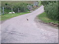
Stepping out!
A Red-legged Partridge on a minor road near Banscol Farm; where Allt na Ceardaich crosses to join the Allt Reidh-Lochan (off left).
Image: © Stanley Howe
Taken: 25 Jun 2007
0.06 miles
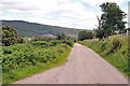
3
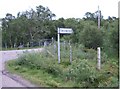
Rhilochan
The Brora to Rogart road climbs away from Strath Brora. This area is unusual for inland Sutherland as it is relatively densely inhabited.
Image: © Richard Webb
Taken: 10 Aug 2015
0.06 miles
6
A new house (2007)
Named 'Benscol Lodge'; by Allt Reidh-Lochan.
Image: © Stanley Howe
Taken: 25 Jun 2007
0.16 miles
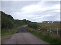
8
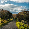
Looking down the minor road at Tannachy
Lairg Windfarm on the horizon
Image: © Peter Moore
Taken: 1 Nov 2016
0.21 miles
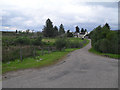
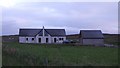
9
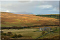
House at Tannachy, Strath Brora, Sutherland
A rural house. The summit of Ben Armine in the background.
Image: © Andrew Tryon
Taken: 30 Oct 2021
0.24 miles
10
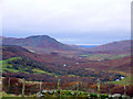
Looking to the head of Strath Brora from Tannachy
Image: © sylvia duckworth
Taken: 2 Nov 2007
0.25 miles