IMAGES TAKEN NEAR TO
East Langwell, ROGART, IV28 3XH
Introduction
This page details the photographs taken nearby to East Langwell, IV28 3XH by members of the Geograph project.
The Geograph project started in 2005 with the aim of publishing, organising and preserving representative images for every square kilometre of Great Britain, Ireland and the Isle of Man.

There are currently over 7.5m images from over14,400 individuals and you can help contribute to the project by visiting https://www.geograph.org.uk
Image Map
Images are licensed for reuse under creativecommons.org/licenses/by-sa/2.0
Notes
- Clicking on the map will re-center to the selected point.
- The higher the marker number, the further away the image location is from the centre of the postcode.
Image Listing (5 Images Found)
Images are licensed for reuse under creativecommons.org/licenses/by-sa/2.0
Image
Details
Distance
2
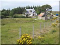
House at East Langwell
The crofting township of East Langwell lies within the parish of Rogart to the north of Strath Fleet. This modern house presumably replaces an original crofters cottage.
Image: © Oliver Dixon
Taken: 23 Jun 2008
0.06 miles
3
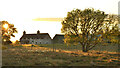
Cottage and Moorland Meadow at Sunset, East Langwell, Sutherland
Normally a bleak area of the country, but dramatically lit up by the late evening sunshine at 9:30pm to create - just for a few moments - a rich pastoral scene not typical of this part of the world.
Image: © Julia Tryon
Taken: 4 Jun 2022
0.14 miles
4
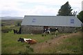
East Langwell Farm
Cattle Shed close to East Langwell Farm
Image: © Graeme Smith
Taken: 3 Jul 2008
0.15 miles