IMAGES TAKEN NEAR TO
Ardersier, INVERNESS, IV2 7SX
Introduction
This page details the photographs taken nearby to IV2 7SX by members of the Geograph project.
The Geograph project started in 2005 with the aim of publishing, organising and preserving representative images for every square kilometre of Great Britain, Ireland and the Isle of Man.

There are currently over 7.5m images from over14,400 individuals and you can help contribute to the project by visiting https://www.geograph.org.uk
Image Map
Images are licensed for reuse under creativecommons.org/licenses/by-sa/2.0
Notes
- Clicking on the map will re-center to the selected point.
- The higher the marker number, the further away the image location is from the centre of the postcode.
Image Listing (26 Images Found)
Images are licensed for reuse under creativecommons.org/licenses/by-sa/2.0
Image
Details
Distance
2
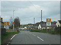
Ardersier : Old Military Road, B9039
A road heading into the village of Ardersier.
Image: © Lewis Clarke
Taken: 23 Apr 2016
0.06 miles
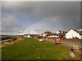
3
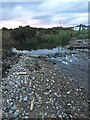
Drainage outflow
Onto the foreshore, just outside Ardersier.
Image: © jeff collins
Taken: 28 Sep 2020
0.06 miles
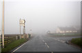
4
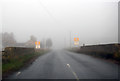
B9039 Entering Ardersier
On a cold and misty morning.
Image: © Peter Bond
Taken: 10 Nov 2014
0.09 miles
5
Highland : Old Military Road, B9039
Approaching Ardersier on the Old Military Road.
Image: © Lewis Clarke
Taken: 23 Apr 2016
0.09 miles
6
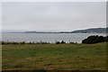
Farmland strip on the edge of the Moray Firth
Image: © Alan Reid
Taken: 25 Jul 2013
0.11 miles
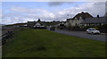
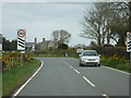
7
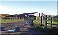
Milton of Connage
Barns and byres on the outskirts of the village of Ardersier.
Image: © Anne Burgess
Taken: 26 Dec 2017
0.12 miles
8
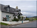
Old Military Road, Ardersier
Attractive old cottage on the firthside road at Ardersier. The road leads to Fort George.
Image: © Colin Smith
Taken: 1 Aug 2011
0.12 miles